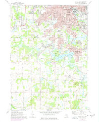
1971 Map of Jackson South
USGS Topo · Published 1978About this map
Jackson expands southward in the early 1970s, transitioning from the dense urban core near City Hall to the sprawling suburbs of Summit and Liberty. The Grand River snakes through the landscape, flanked by established municipal landmarks like Mount Evergreen Cem and the Sparks Foundation County Park. This era of development is marked by the presence of numerous educational institutions, from local elementary schools like Harrington Sch to the expansive campus of Jackson Community College.
Find a feature on this map
104 named features on this map. Tap any name to fly to it.
Don’t see what you’re looking for? This feature index may not catch every label — zoom into the map to look around manually.
Map Details
Editions of this 1971 Jackson South Map
3 editions found
Other maps of this area

1919 · Springport
USGS Topo · 1:62,500

1919 · Rives Junction
USGS Topo · 1:62,500

1921 · Rives Junction
USGS Topo · 1:62,500

1921 · Springport
USGS Topo · 1:62,500

1935 · Jackson
USGS Topo · 1:48,000

1939 · Jackson
USGS Topo · 1:62,500

1948 · Spring Arbor
USGS Topo · 1:62,500

1949 · Spring Arbor
USGS Topo · 1:62,500

1958 · Grand Rapids
USGS Topo · 1:250,000

1961 · Grand Rapids
USGS Topo · 1:250,000