1970s Maps of Keweenaw County, Michigan
Explore 3 historic maps of Keweenaw County from the 1970s. These maps offer a rare glimpse into what life looked like during the 1970s — showing old roads, neighborhoods, homes, and landmarks that have changed or disappeared over time.
Whether you're researching your family's past, planning a metal detecting trip, or studying how Keweenaw County's landscape evolved across the 1970s, these high-resolution maps are a powerful tool for exploring the history of this region.
- Focus on a specific era: All maps on this page are from the 1970s, giving you a focused view of this time period.
- See what’s changed: Compare century-old streets, trails, and buildings to today's modern landscape using overlays and satellite layers.
- Research with precision: Use these maps for genealogy, historical research, land use analysis, or educational projects.
- View, download, or print: Maps are fully viewable online in high resolution, and can be downloaded or printed for your own records.
Start exploring Keweenaw County's history through authentic maps from the 1970s. This is your window into the past.
Keweenaw County, MI maps
(3)- 1978 Map of Muggun Creek
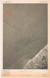 1978 Muggun Creek1978 Print · USGSThe northern shore of Michigan's Upper Peninsula meets the deep waters of Lake Superior in the late 1970s. Trace the coastal mouth of Muggun Creek and examine land lines from a previous 1946 survey.
 - 1978 Map of Mohawk
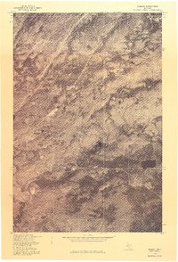 1978 Mohawk1978 Print · USGSUpper Peninsula mining history comes into focus in the late 1970s as aerial photography reveals the layout of these Keweenaw copper country towns. Genealogists and historians can trace the clearings and homes around Mohawk and Fulton in their late twentieth-century context.
 - 1978 Map of Rice Lake
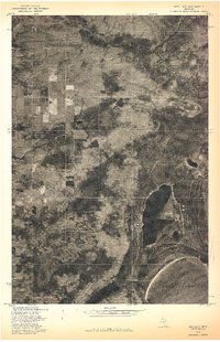 1978 Rice Lake1978 Print · USGSThe Keweenaw Peninsula shoreline meets the deep woods of Houghton County in the late seventies. Researchers can study the unmapped timber and wetland patterns around Rice Lake and the Lake Superior coast.
End of results
Showing maps 1-3 of 3
Frequently asked questions
- What are the different types of historical maps available for Keweenaw County?
- What is the oldest map of Keweenaw County?
- Where can I purchase historical maps of Keweenaw County for my home or office?
- Where can I download high-res historical maps of Keweenaw County?
- Are there historical topographic maps available for Keweenaw County?
- Is there historical aerial imagery available for Keweenaw County?
- Where are historical maps of Keweenaw County sourced from?