2020s Maps of Keweenaw County, Michigan
Explore 36 historic maps of Keweenaw County from the 2020s. These maps offer a rare glimpse into what life looked like during the 2020s — showing old roads, neighborhoods, homes, and landmarks that have changed or disappeared over time.
Whether you're researching your family's past, planning a metal detecting trip, or studying how Keweenaw County's landscape evolved across the 2020s, these high-resolution maps are a powerful tool for exploring the history of this region.
- Focus on a specific era: All maps on this page are from the 2020s, giving you a focused view of this time period.
- See what’s changed: Compare century-old streets, trails, and buildings to today's modern landscape using overlays and satellite layers.
- Research with precision: Use these maps for genealogy, historical research, land use analysis, or educational projects.
- View, download, or print: Maps are fully viewable online in high resolution, and can be downloaded or printed for your own records.
Start exploring Keweenaw County's history through authentic maps from the 2020s. This is your window into the past.
Keweenaw County, MI maps
(36)- 2023 Map of Bruneau Creek, 2023 Print
 2023 Bruneau Creek2023 Print · USGSThe Keweenaw Peninsula backcountry in the 2020s remains a terrain of high ridges and winding river systems. Genealogists and researchers can trace the roads around Mount Horace Greeley or follow the waters of Bruneau Creek to Lake Gratiot.
 - 2023 Map of Point Isabelle, 2023 Print
 2023 Point Isabelle2023 Print · USGSThe southern coast of the Keweenaw Peninsula remains a remote stretch of Lake Superior shoreline in this recent survey. Local historians can trace the paths of Gay Rd and Montgomery Point Rd as they navigate the woods near Point Isabelle and Bete Grise Bay.
 - 2023 Map of Mohawk, 2023 Print
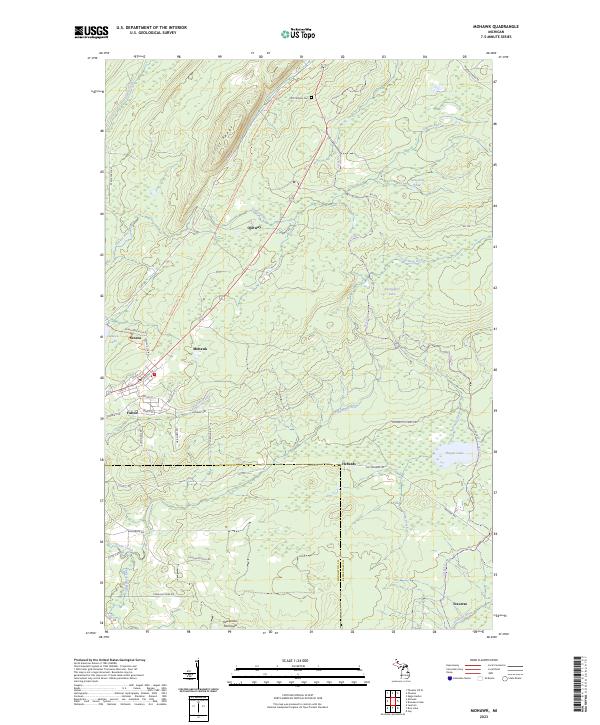 2023 Mohawk2023 Print · USGSThe northern Keweenaw Peninsula is captured here in the early twenty-first century, showing the enduring layout of historic mining communities. Researchers can trace local lineage through the Cliff Catholic Cem or explore the street grids of Mohawk and Fulton.
 - 2023 Map of Windigo OE W, 2023 Print
 2023 Windigo OE W2023 Print · USGSIsle Royale in Michigan's Keweenaw County is depicted here in recent years as its northern shoreline meets the international boundary. Genealogists and park enthusiasts can trace the limits of Isle Royale National Park against Lake Superior.
 - 2023 Map of Phoenix, 2023 Print
 2023 Phoenix2023 Print · USGSKeweenaw County's rocky northern shore is documented here at the mouth of the Eagle River. Genealogists and local historians can trace the inland settlements of Phoenix and Eagle Nest, or locate family sites at the Eagle River Cem and Cliff Cem.
 - 2023 Map of Phoenix OE W, 2023 Print
 2023 Phoenix OE W2023 Print · USGSThe Keweenaw Peninsula shoreline meets the deep waters of the Great Lakes in this contemporary coastal study. Researchers can locate maritime hazards like Hutchinson Shoal and trace local access roads including 7 Mile Point Rd.
 - 2023 Map of Gay, 2023 Print
 2023 Gay2023 Print · USGSThe Keweenaw Peninsula coastline comes into focus in this recent survey of the Michigan lakefront. Researchers can trace the roads and waterways around Gay and Snowshoe, including Traverse Point and the winding course of the Tobacco River.
 - 2023 Map of Malone Bay, 2023 Print
 2023 Malone Bay2023 Print · USGSIsle Royale's southern coast is a complex world of rocky islands and deep harbors as it appeared in recent years. Researchers can trace the rugged shoreline from Malone Bay to remote outcrops like Menagerie Island and Stone House Island.
 - 2023 Map of Feldtmann Ridge, 2023 Print
 2023 Feldtmann Ridge2023 Print · USGSIsle Royale remains a pristine wilderness in this recent survey of its southwestern coast and ridges. Hikers and researchers can trace the Feldtmann Ridge Trl past Lake Halloran and identify coastal landmarks like Long Point and Attwood Beach.
 - 2023 Map of Feldtmann Lake, 2023 Print
 2023 Feldtmann Lake2023 Print · USGSIsle Royale's southwestern tip is documented here in the early twenty-first century, showing the intersection of coastal reefs and inland trails. Hikers and researchers can trace the paths between Grace Harbor, the high ground of Feldtmann Ridge, and the shores of Feldtmann Lake.
 - 2023 Map of Passage Island OE N, 2023 Print
 2023 Passage Island OE N2023 Print · USGSThe northern waters of Keweenaw County are captured here in the early twenty-first century, showing the remote international boundary in the middle of the lake. Researchers can locate the Gull Islands and trace the limits of the Isle Royale National Park.
 - 2023 Map of Manitou Island OE E, 2023 Print
 2023 Manitou Island OE E2023 Print · USGSManitou Island and the surrounding Lake Superior waters are meticulously charted in this modern survey of Michigan's northern reaches. Marine historians and local researchers can trace the coastal contours of Fishermans Bay, Square Bay, and the isolated Manitou Island.
 - 2023 Map of Sugar Mountain, 2023 Print
 2023 Sugar Mountain2023 Print · USGSThe wilderness of Isle Royale is mapped here in the early twenty-first century, showing the island's high ridges and remote shoreline. Trace the paths of the Island Mine Trl or locate the Isle Royale Cem near the waters of Siskiwit Bay.
 - 2023 Map of Rice Lake, 2023 Print
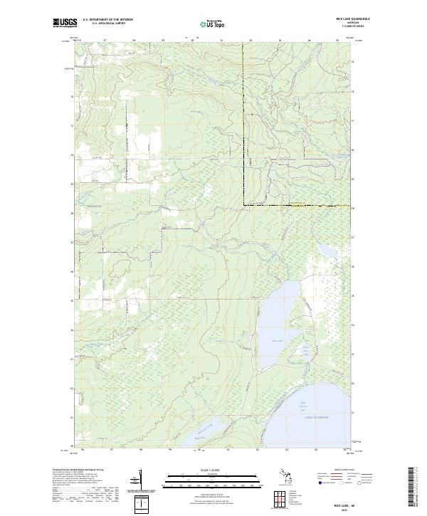 2023 Rice Lake2023 Print · USGSThe Keweenaw Peninsula shoreline meets the deep waters of Lake Superior in this modern survey of the Michigan coast. Researchers can trace the drainage of the Traverse River into Little Traverse Bay and locate landmarks like Rice Lake and Mud Lake.
 - 2023 Map of Deer Lake, 2023 Print
 2023 Deer Lake2023 Print · USGSThe Keweenaw Peninsula shoreline meets the deep waters of the Great Lakes in this contemporary survey of northern Michigan. Trace the remote waterways of Lake Gratiot, Deer Lake, and Black Rock Point along the jagged coast of Betsy Bay.
 - 2023 Map of Rock Harbor Lodge, 2023 Print
 2023 Rock Harbor Lodge2023 Print · USGSIsle Royale’s rugged northeastern shoreline and the enclave at Rock Harbor Lodge are mapped here in the early twenty-first century. Outdoor researchers and maritime historians can trace the complex archipelago of Porter Island and the reach of Scoville Point.
 - 2023 Map of Todd Harbor, 2023 Print
 2023 Todd Harbor2023 Print · USGSIsle Royale's rugged northern coast and interior ridges are captured in this contemporary survey of the national park wilderness. Hikers and researchers can trace the paths of the Minong Ridge Trl and Hatchet Lake Trl past landmarks like Mt Siskiwit and Todd Harbor.
 - 2023 Map of McCargoe Cove, 2023 Print
 2023 McCargoe Cove2023 Print · USGSKeweenaw County's northernmost reaches appear in this modern survey of the island wilderness near the Canadian border. Researchers can trace the rugged coastline of Amygdaloid Island and identify landmarks like Pine Mountain and Pickerel Cove.
 - 2023 Map of Muggun Creek, 2023 Print
 2023 Muggun Creek2023 Print · USGSThe Keweenaw Peninsula shoreline is captured here as it appeared in the early 2020s, marking the remote border of Keweenaw Co and Houghton Co. Trace the coastal drainage of Muggun Creek and Gardeners Creek along Lake Shore Dr.
 - 2023 Map of Point Houghton, 2023 Print
 2023 Point Houghton2023 Print · USGSKeweenaw County's island wilderness is captured in the early 2020s, showing the intersection of dramatic ridges and the cold waters of Lake Superior. Researchers can trace the rugged shoreline from Fishermans Home Cove to the high vantage of Ishpeming Point.
 - 2023 Map of Little Todd Harbor, 2023 Print
 2023 Little Todd Harbor2023 Print · USGSThe northwestern shores of Isle Royale are captured in this modern survey of Keweenaw County's wilderness. Trace the remote coast from Thomsonite Beach to Little Todd Harbor, following the footpaths of the Minong Ridge Trl through the park.
 - 2023 Map of Windigo, 2023 Print
 2023 Windigo2023 Print · USGSIsle Royale's southwestern tip and the sheltered waters of Washington Harbor are shown here in the 2020s. Hikers and researchers can trace the intricate network of the Minong Ridge Trl and locate remote landmarks like Agate Beach and Windigo.
 - 2023 Map of Lake Richie, 2023 Print
 2023 Lake Richie2023 Print · USGSIsle Royale in the early 2020s remains a sanctuary of linear ridges and interior lakes defined by its unique archipelago geography. Hikers and historians can trace traditional routes like the Indian Portage Trl connecting Lake Richie to the sheltered waters of Chippewa Harbor.
 - 2023 Map of Lake Richie OE S, 2023 Print
 2023 Lake Richie OE S2023 Print · USGSKeweenaw County's remote island wilderness is captured in the early 2020s, revealing the intersection of land and lake. Maritime historians can locate Glenlyon Shoal and trace the rocky shoreline from Vodrey Harbor to Little Greenstone Beach.
 - 2023 Map of Ahmeek, 2023 Print
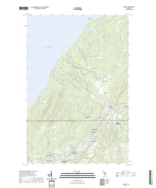 2023 Ahmeek2023 Print · USGSThe Keweenaw Peninsula’s storied mining district is mapped here during its modern era of preservation and recreation. Researchers can trace the layout of historic settlements like Ahmeek, Mohawk, and Bumbletown alongside the Keweenaw National Historical Park.
Showing maps 1-25 of 36
Frequently asked questions
- What are the different types of historical maps available for Keweenaw County?
- What is the oldest map of Keweenaw County?
- Where can I purchase historical maps of Keweenaw County for my home or office?
- Where can I download high-res historical maps of Keweenaw County?
- Are there historical topographic maps available for Keweenaw County?
- Is there historical aerial imagery available for Keweenaw County?
- Where are historical maps of Keweenaw County sourced from?