1940s Maps of Elba Township, Michigan
Explore 3 historic maps of Elba Township from the 1940s. These maps offer a rare glimpse into what life looked like during the 1940s — showing old roads, neighborhoods, homes, and landmarks that have changed or disappeared over time.
Whether you're researching your family's past, planning a metal detecting trip, or studying how Elba Township's landscape evolved across the 1940s, these high-resolution maps are a powerful tool for exploring the history of this region.
- Focus on a specific era: All maps on this page are from the 1940s, giving you a focused view of this time period.
- See what’s changed: Compare century-old streets, trails, and buildings to today's modern landscape using overlays and satellite layers.
- Research with precision: Use these maps for genealogy, historical research, land use analysis, or educational projects.
- View, download, or print: Maps are fully viewable online in high resolution, and can be downloaded or printed for your own records.
Start exploring Elba Township's history through authentic maps from the 1940s. This is your window into the past.
Elba Township, MI maps
(3)- 1943 Map of Metamora, 1964 Print
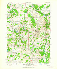 1943 Metamora1964 Print · USGSLapeer County during the early 1940s shows a landscape of small villages and rural schools along the Michigan Central line. Genealogists can trace family names through landmarks like Harris Cem, Newark Sch, and Lake Minnewanna.
 - 1945 Map of Hadley
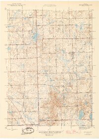 1945 Hadley1945 Print · USGSLapeer County at the end of the war reveals a quiet landscape of agricultural homesteads and numerous small lakes. Genealogists can trace family roots at Green Corners Cem or locate rural landmarks like Kipp Sch and the Sawmill near Sawmill Lake.2 unique versions available
 - 1946 Map of Metamora
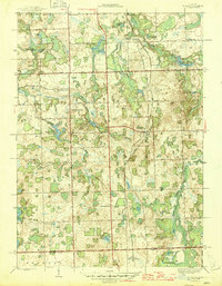 1946 Metamora1946 Print · USGSLapeer County was a landscape of small farms and numerous glacial lakes during the mid-1940s. Researchers can trace the Michigan Central rail corridor and locate community landmarks like Farmers Creek Cem, Camp Metamora, and several rural schools.2 unique versions available
End of results
Showing maps 1-3 of 3
Top cities near Elba Township
- Flint historical maps
- Orion Charter Township historical maps
- Independence Charter Township historical maps
- Burton historical maps
- Oxford Charter Township historical maps
- Oakland Charter Township historical maps
See more
Top neighborhoods of Elba Township
Frequently asked questions
- What are the different types of historical maps available for Elba Township?
- What is the oldest map of Elba Township?
- Where can I purchase historical maps of Elba Township for my home or office?
- Where can I download high-res historical maps of Elba Township?
- Are there historical topographic maps available for Elba Township?
- Is there historical aerial imagery available for Elba Township?
- Where are historical maps of Elba Township sourced from?