1950s Maps of Lenawee County, Michigan
Explore 6 historic maps of Lenawee County from the 1950s. These maps offer a rare glimpse into what life looked like during the 1950s — showing old roads, neighborhoods, homes, and landmarks that have changed or disappeared over time.
Whether you're researching your family's past, planning a metal detecting trip, or studying how Lenawee County's landscape evolved across the 1950s, these high-resolution maps are a powerful tool for exploring the history of this region.
- Focus on a specific era: All maps on this page are from the 1950s, giving you a focused view of this time period.
- See what’s changed: Compare century-old streets, trails, and buildings to today's modern landscape using overlays and satellite layers.
- Research with precision: Use these maps for genealogy, historical research, land use analysis, or educational projects.
- View, download, or print: Maps are fully viewable online in high resolution, and can be downloaded or printed for your own records.
Start exploring Lenawee County's history through authentic maps from the 1950s. This is your window into the past.
Lenawee County, MI maps
(6)- 1951 Map of Berkey, 1952 Print
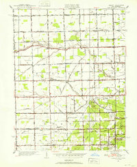 1951 Berkey1952 Print · USGSThis Lucas County landscape in the early fifties shows a rural community defined by family farms and the Michigan-Ohio border. Genealogists can locate family landmarks like the Wolfinger Cemetery, Sharples Church, and schools like Mulberry School.3 unique versions available
 - 1953 Map of Fort Wayne, 1963 Print
 1953 Fort Wayne1963 Print · USGSNortheast Indiana and its neighboring borderlands in Michigan and Ohio appear here during a peak era of rail and road expansion. Researchers can trace the massive rail networks of the Nickel Plate Road and Wabash or locate lakeside landmarks like Lake Wawasee and Clear Lake.4 unique versions available
 - 1954 Map of Detroit
 1954 Detroit1954 Print · USGSThe Detroit metro and its Ontario neighbors are shown at the height of the mid-century industrial era, just as the suburbs were rapidly expanding. Researchers can trace the massive rail networks of the Wabash Railroad or locate landmarks like Grosse Ile and Selfridge Air Force Base.
 - 1956 Map of Fort Wayne
 1956 Fort Wayne1956 Print · USGSThe tri-state borderlands of Indiana, Michigan, and Ohio are captured here in the mid-fifties, centered on the growing industrial hub of Fort Wayne. Researchers can trace the heavy rail lines of the New York Central and Pennsylvania alongside prominent water features like Lake Wawasee and the Maumee River.2 unique versions available
 - 1956 Map of Toledo, 1968 Print
 1956 Toledo1968 Print · USGSNorthwest Ohio and the Lake Erie shoreline are shown in detail during the late fifties, showcasing a landscape of heavy industry, railroads, and island communities. Genealogists and historians can trace rail networks like the Chesapeake & Ohio RR or locate landmarks such as the Erie Proving Ground and Kelleys Island.4 unique versions available
 - 1958 Map of Grand Rapids, 1973 Print
 1958 Grand Rapids1973 Print · USGSSouthern Michigan at the peak of the postwar era shows a landscape of burgeoning cities and new interstate highways. Trace family roots and regional growth in Grand Rapids, Battle Creek, and the glacial lake country around Gun Lake or Gull Lake.2 unique versions available
End of results
Showing maps 1-6 of 6
Top cities of Lenawee County
- Adrian historical maps
- Tecumseh historical maps
- Rollin Township historical maps
- Hudson historical maps
- Morenci historical maps
- Addison historical maps
See more
Frequently asked questions
- What are the different types of historical maps available for Lenawee County?
- What is the oldest map of Lenawee County?
- Where can I purchase historical maps of Lenawee County for my home or office?
- Where can I download high-res historical maps of Lenawee County?
- Are there historical topographic maps available for Lenawee County?
- Is there historical aerial imagery available for Lenawee County?
- Where are historical maps of Lenawee County sourced from?