1970s Maps of Lenawee County, Michigan
Explore 5 historic maps of Lenawee County from the 1970s. These maps offer a rare glimpse into what life looked like during the 1970s — showing old roads, neighborhoods, homes, and landmarks that have changed or disappeared over time.
Whether you're researching your family's past, planning a metal detecting trip, or studying how Lenawee County's landscape evolved across the 1970s, these high-resolution maps are a powerful tool for exploring the history of this region.
- Focus on a specific era: All maps on this page are from the 1970s, giving you a focused view of this time period.
- See what’s changed: Compare century-old streets, trails, and buildings to today's modern landscape using overlays and satellite layers.
- Research with precision: Use these maps for genealogy, historical research, land use analysis, or educational projects.
- View, download, or print: Maps are fully viewable online in high resolution, and can be downloaded or printed for your own records.
Start exploring Lenawee County's history through authentic maps from the 1970s. This is your window into the past.
Lenawee County, MI maps
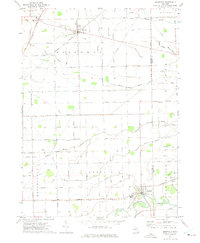
(5)- 1971 Map of Cement City, 1973 Print
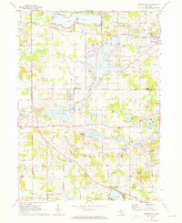 1971 Cement City1973 Print · USGSThe Irish Hills region in the early seventies shows a community balanced between traditional rail-side industry and growing lakeside recreation. Trace family roots at Sanford Cem, locate the old Penn Central tracks, or find long-standing landmarks like St Rita Ch.2 unique versions available
 - 1972 Map of Palmyra, 1975 Print
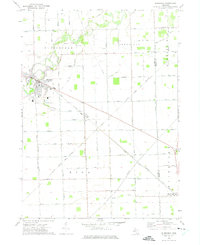
 1972 Palmyra1975 Print · USGSSoutheast Michigan's agricultural heartland is captured here in the early seventies, centered on the winding Raisin River. Genealogists and historians can trace family locations near Ogden Center, find rural landmarks like Zion Ch, and follow the path of the Detroit and Ironton rail line.
 - 1972 Map of Blissfield, 1975 Print
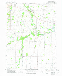
 1972 Blissfield1975 Print · USGSSoutheastern Michigan agriculture and transit converge during the early seventies as the Raisin River meanders toward Lake Erie. Genealogists can trace family footprints across the Lenawee and Monroe border, locating sites like Logan Cem, Riga Cem, and the village of Ottawa Lake.
 - 1972 Map of Tecumseh South, 1975 Print
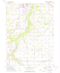 1972 Tecumseh South1975 Print · USGSSoutheast Michigan in the early 1970s reveals a landscape where heavy rail and the Raisin River dominate the terrain. Genealogists and local historians can trace the foundations of Raisin Center and find family-named sites like McLain Cem and Lenawee Junction.
 - 1972 Map of Deerfield, 1975 Print
 1972 Deerfield1975 Print · USGSSoutheast Michigan in the early 1970s was a landscape where rail lines and river bends still shaped local commerce. Researchers can trace the path of the Norfolk and Western through Britton or locate genealogical sites like Grace Ch and the Ridgeway Cem.2 unique versions available
End of results
Showing maps 1-5 of 5
Top cities of Lenawee County
- Adrian historical maps
- Tecumseh historical maps
- Rollin Township historical maps
- Hudson historical maps
- Morenci historical maps
- Addison historical maps
See more
Frequently asked questions
- What are the different types of historical maps available for Lenawee County?
- What is the oldest map of Lenawee County?
- Where can I purchase historical maps of Lenawee County for my home or office?
- Where can I download high-res historical maps of Lenawee County?
- Are there historical topographic maps available for Lenawee County?
- Is there historical aerial imagery available for Lenawee County?
- Where are historical maps of Lenawee County sourced from?