1970s Maps of Livingston County, Michigan
Explore 8 historic maps of Livingston County from the 1970s. These maps offer a rare glimpse into what life looked like during the 1970s — showing old roads, neighborhoods, homes, and landmarks that have changed or disappeared over time.
Whether you're researching your family's past, planning a metal detecting trip, or studying how Livingston County's landscape evolved across the 1970s, these high-resolution maps are a powerful tool for exploring the history of this region.
- Focus on a specific era: All maps on this page are from the 1970s, giving you a focused view of this time period.
- See what’s changed: Compare century-old streets, trails, and buildings to today's modern landscape using overlays and satellite layers.
- Research with precision: Use these maps for genealogy, historical research, land use analysis, or educational projects.
- View, download, or print: Maps are fully viewable online in high resolution, and can be downloaded or printed for your own records.
Start exploring Livingston County's history through authentic maps from the 1970s. This is your window into the past.
Livingston County, MI maps
(8)- 1972 Map of Perry, 1975 Print
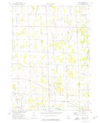
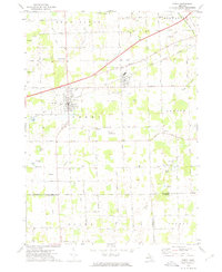 1972 Perry1975 Print · USGSMid-century Perry and Morrice are captured here as the Grand Trunk Western railroad defines the local industry. Researchers can trace family roots through Roselawn Cem or locate the private Dysinger Landing Strip.
 - 1972 Map of Corunna SE, 1975 Print
 1972 Corunna SE1975 Print · USGSSoutheastern Shiawassee County is captured here in the early seventies, showing a landscape of small agricultural settlements and winding river valleys. Family historians can trace the locations of the Gaylord Cem, the community at Antrim Center, and the rural Antrim Ch.
 - 1973 Map of Parkers Corners, 1977 Print
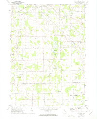
 1973 Parkers Corners1977 Print · USGSLivingston County maintains its quiet agricultural character in the 1970s, as the headwaters of the Red Cedar River wind through rural townships. Researchers can trace family history through numerous landmark burial grounds like Munsell Cem and Harford Cem or locate the small community of Lamoreaux.
 - 1973 Map of Gregory, 1977 Print
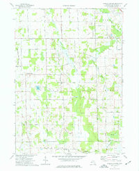
 1973 Gregory1977 Print · USGSLivingston County lake country is captured here in the early 1970s, showcasing a landscape of summer camps and small settlements. Researchers can trace family history at Unadilla Cem, locate the Richmond Airport, or follow the Old RR Grade through the township.3 unique versions available
 - 1973 Map of Millville, 1977 Print
 1973 Millville1977 Print · USGSThe rural Ingham County countryside of the 1970s is preserved here, showing the quiet crossroads and farming tracts before modern development. Researchers can trace family roots at Mount Pleasant Cemetery or locate old community hubs like White Oak and the North Stockbridge Community Church.
 - 1973 Map of Fowlerville, 1977 Print
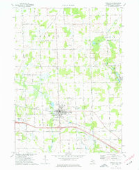 1973 Fowlerville1977 Print · USGSFowlerville and the surrounding Livingston County townships are captured here in the early 1970s, showcasing a rural landscape defined by family farms and rail transport. Researchers can trace the Chesapeake and Ohio line, locate family plots in Conway Cem, or find the Free Methodist Ch.
 - 1973 Map of Webberville, 1977 Print
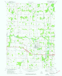 1973 Webberville1977 Print · USGSAgricultural life in Ingham County during the early seventies centers on Webberville and its vital rail and road links. Genealogists can locate several historic burial grounds including Rowley Cem and Judd Cem alongside the Red Cedar River.
 - 1973 Map of Stockbridge, 1977 Print
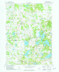
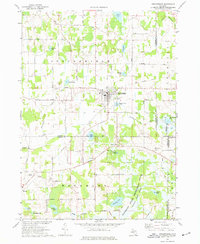 1973 Stockbridge1977 Print · USGSStockbridge and its glacial lake surroundings are captured here in the early seventies, spanning the borders of Ingham, Livingston, and Jackson Counties. Genealogists and local historians can locate several family-named landmarks and rural burial grounds such as Oaklawn Cem, Munith Cem, and the Old Railroad Grade.
End of results
Showing maps 1-8 of 8
Top cities of Livingston County
- Hamburg Township historical maps
- Genoa Charter Township historical maps
- Green Oak Charter Township historical maps
- Brighton Charter Township historical maps
- Hartland Township historical maps
- Oceola Township historical maps
See more
Frequently asked questions
- What are the different types of historical maps available for Livingston County?
- What is the oldest map of Livingston County?
- Where can I purchase historical maps of Livingston County for my home or office?
- Where can I download high-res historical maps of Livingston County?
- Are there historical topographic maps available for Livingston County?
- Is there historical aerial imagery available for Livingston County?
- Where are historical maps of Livingston County sourced from?