1960s Maps of Livingston County, Michigan
Explore 16 historic maps of Livingston County from the 1960s. These maps offer a rare glimpse into what life looked like during the 1960s — showing old roads, neighborhoods, homes, and landmarks that have changed or disappeared over time.
Whether you're researching your family's past, planning a metal detecting trip, or studying how Livingston County's landscape evolved across the 1960s, these high-resolution maps are a powerful tool for exploring the history of this region.
- Focus on a specific era: All maps on this page are from the 1960s, giving you a focused view of this time period.
- See what’s changed: Compare century-old streets, trails, and buildings to today's modern landscape using overlays and satellite layers.
- Research with precision: Use these maps for genealogy, historical research, land use analysis, or educational projects.
- View, download, or print: Maps are fully viewable online in high resolution, and can be downloaded or printed for your own records.
Start exploring Livingston County's history through authentic maps from the 1960s. This is your window into the past.
Livingston County, MI maps
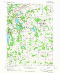
(16)- 1961 Map of Grand Rapids
 1961 Grand Rapids1961 Print · USGSSouthern Michigan at the dawn of the 1960s reveals a region shaped by major river systems and a robust rail network. Trace mid-century industrial growth and land use from Grand Rapids to the Fort Custer Military Reservation and Gun Lake.
 - 1961 Map of Detroit, 1973 Print
 1961 Detroit1973 Print · USGSThe international border between Michigan and Ontario was a bustling industrial corridor in the early sixties. Researchers can trace the transit networks and riverfront infrastructure connecting Detroit to Windsor via the Detroit-Windsor Tunnel and major air hubs like Willow Run Airport.2 unique versions available
 - 1962 Map of Grand Rapids
 1962 Grand Rapids1962 Print · USGSMid-century Southern Michigan is mapped here at a time of massive growth, showing the expanding urban footprints of Grand Rapids and Lansing. Researchers can trace the legacy of the Grand Trunk Western RR, find historic boundaries of the Fort Custer Military Reservation, or locate sporting camps around Gun Lake.2 unique versions available
 - 1965 Map of Detroit
 1965 Detroit1965 Print · USGSThe industrial corridor between Michigan and Ontario is captured here at mid-century, showing the dense rail and river networks of the Great Lakes. Local historians can trace the paths of the Grand Trunk Western RR and locate key landmarks like Selfridge Air Force Base and Grosse Ile.
 - 1965 Map of South Lyon, 1967 Print
 1965 South Lyon1967 Print · USGSSoutheast Michigan in the mid-sixties reveals a countryside defined by the Chesapeake and Ohio Railroad and numerous glacial lakes. Trace early burial grounds like Old Irish Cem and Rose Cem, alongside the schoolyards of Sayre Sch.4 unique versions available
 - 1965 Map of Pinckney, 1967 Print
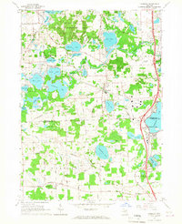
 1965 Pinckney1967 Print · USGSThe lake-rich landscape of Livingston and Washtenaw counties is captured here in the mid-sixties, centered on the village of Pinckney. Genealogists and researchers can trace local landmarks like Placeway Cem, the rural settlement of Hell, and the scientific facilities atop Peach Mountain.4 unique versions available
 - 1965 Map of Hamburg, 1967 Print
 1965 Hamburg1967 Print · USGSThe lake country of Livingston and Washtenaw Counties is captured here in the mid-1960s as residential settlements grew around the Huron River. Local historians can trace the rail paths of the Ann Arbor RR or locate landmarks like the Boys Training Camp and Pettysville.4 unique versions available
 - 1968 Map of Howell, 1970 Print
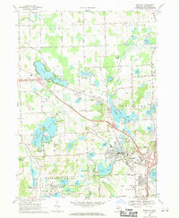
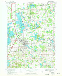
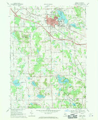 1968 Howell1970 Print · USGSHowell and its surrounding townships show a mix of civic growth and preserved wetlands during the late sixties. Researchers can trace historic family plots at Lakeview Cem and Mount Olivet Cem or locate institutional landmarks like the Howell State Hospital.3 unique versions available
 - 1968 Map of Brighton, 1970 Print
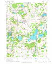
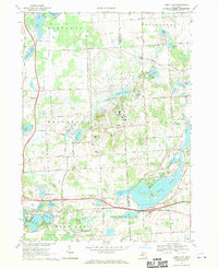
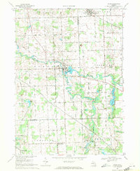
 1968 Brighton1970 Print · USGSLivingston County in the late sixties reveals a landscape of lakeside communities and growing recreational hubs. Genealogists and local historians can trace family markers at Chilson Cem, locate the old Birkenstock Sch, or study the rail operations of the Chesapeake and Ohio.3 unique versions available
 - 1968 Map of Kent Lake, 1970 Print
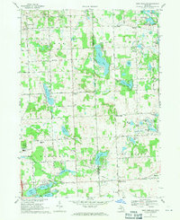
 1968 Kent Lake1970 Print · USGSLivingston and Oakland Counties are shown during a period of significant recreational development in the late sixties. Genealogists and local researchers can trace the Chesapeake and Ohio rail line, Brighton Cemetery, and the School Lake School.6 unique versions available
 - 1968 Map of Hartland, 1971 Print
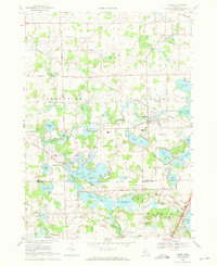
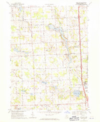 1968 Hartland1971 Print · USGSLivingston County in the late sixties shows a landscape of small agricultural settlements and rising recreational use. Genealogists can locate family sites at Deerfield Center Cem and Smith Cem, or trace the mill history at Hartland Millpond.2 unique versions available
 - 1968 Map of Oak Grove, 1971 Print
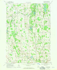 1968 Oak Grove1971 Print · USGSLivingston County's rural heartland is captured here in the late sixties as the C & O rail line still serves the village of Oak Grove. Genealogists can locate family landmarks like Sanford Cem, Cohoctah Ch, and the Livingston County Airport.2 unique versions available
 - 1968 Map of West Highland, 1971 Print
 1968 West Highland1971 Print · USGSLivingston and Oakland counties are captured here in the late sixties, a landscape of family farms and emerging lakefront camps. Genealogists and local historians can trace the sites of Beebe Cem, Tyrone Center, and the Hartland Millpond during this period of growth.3 unique versions available
 - 1969 Map of Fenton, 1971 Print
 1969 Fenton1971 Print · USGSFenton and Holly are captured here in the late sixties as the lakefront communities of southern Michigan grew around their rail and river hubs. Genealogists and researchers can trace local landmarks like Oakwood Cemetery, Patterson Sch, and the Grand Trunk Western railroad line.3 unique versions available
 - 1969 Map of Byron, 1971 Print
 1969 Byron1971 Print · USGSByron and the Shiawassee River valley are captured here in the late sixties, showing a landscape of small villages and glacial lakes. Trace family history at Oakwood Cem or explore old local landmarks like the Byron Millpond and Lyndee Landing Strip.3 unique versions available
 - 1969 Map of Linden, 1971 Print
 1969 Linden1971 Print · USGSLinden and the surrounding lake country of southern Michigan are shown here in the late sixties as residential and rail infrastructure expanded. Genealogists can locate several historic burial grounds like Fairview Cem and trace the Grand Trunk Western line as it serves the village.3 unique versions available
End of results
Showing maps 1-16 of 16
Top cities of Livingston County
- Hamburg Township historical maps
- Genoa Charter Township historical maps
- Green Oak Charter Township historical maps
- Brighton Charter Township historical maps
- Hartland Township historical maps
- Oceola Township historical maps
See more
Frequently asked questions
- What are the different types of historical maps available for Livingston County?
- What is the oldest map of Livingston County?
- Where can I purchase historical maps of Livingston County for my home or office?
- Where can I download high-res historical maps of Livingston County?
- Are there historical topographic maps available for Livingston County?
- Is there historical aerial imagery available for Livingston County?
- Where are historical maps of Livingston County sourced from?