1950s Maps of Ewing Township, Michigan
Explore 11 historic maps of Ewing Township from the 1950s. These maps offer a rare glimpse into what life looked like during the 1950s — showing old roads, neighborhoods, homes, and landmarks that have changed or disappeared over time.
Whether you're researching your family's past, planning a metal detecting trip, or studying how Ewing Township's landscape evolved across the 1950s, these high-resolution maps are a powerful tool for exploring the history of this region.
- Focus on a specific era: All maps on this page are from the 1950s, giving you a focused view of this time period.
- See what’s changed: Compare century-old streets, trails, and buildings to today's modern landscape using overlays and satellite layers.
- Research with precision: Use these maps for genealogy, historical research, land use analysis, or educational projects.
- View, download, or print: Maps are fully viewable online in high resolution, and can be downloaded or printed for your own records.
Start exploring Ewing Township's history through authentic maps from the 1950s. This is your window into the past.
Ewing Township, MI maps
(11)- 1950 Map of Gladstone NW
 1950 Gladstone NW1950 Print · USGSThe Upper Peninsula logging and rail landscape comes alive in this mid-century survey of the Escanaba River valley. Genealogists can locate family-named landmarks like Larsons Camp and rural sites such as St Nicholas Sch and the hamlet of Cornell.
 - 1951 Map of Helena SW
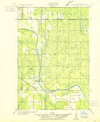
 1951 Helena SW1951 Print · USGSMarquette County's logging and rail corridor is captured here in the early 1950s, showing the intersection of timber camps and rural school life. Researchers can trace the Escanaba and Lake Superior line to Watson, the Arnold PO, and the Finnish Sch.
 - 1951 Map of Helena
 1951 Helena1951 Print · USGSMarquette County in the early thirties shows a landscape of river-driven industry and rural school districts. Genealogists and historians can trace the foundations of local education at Ewing Sch and Lincoln Sch or locate the sites of Finn Camp and Sherkeys Camp.2 unique versions available
 - 1951 Map of Helena NE
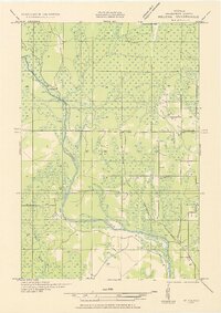
 1951 Helena NE1951 Print · USGSMarquette County's interior timberlands and marshes come into focus in the early 1950s, showing a landscape defined by seasonal outposts and rail transit. Genealogists and historians can trace old sites like Rochenon Camp, Helena, and the Parker Spur rail siding.
 - 1951 Map of Helena NW
 1951 Helena NW1951 Print · USGSMarquette County’s interior during the early 1950s was a landscape of remote camps and heavy industry centered on the Escanaba River. Genealogists and historians can trace old logging outposts like Faucett Camp and the rail operations of the Chicago and North Western.
 - 1954 Map of Escanaba, 1967 Print
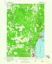
 1954 Escanaba1967 Print · USGSThe Upper Peninsula and Door County shorelines meet here in the mid-fifties, showing the vital maritime and timber networks of the Great Lakes. Researchers can trace historic rail lines, old fire lookouts like the Stonington Fire Tower, and island settlements such as Washington Island.2 unique versions available
 - 1957 Map of Escanaba
 1957 Escanaba1957 Print · USGSThe Upper Peninsula and Door County shorelines meet in the mid-fifties, capturing a landscape of timber, iron, and maritime trade. Genealogists and local historians can trace the Chicago & North Western RR through settlements like Hermansville or locate St Vitals Church and the Potawatome Indian Reservation.
 - 1958 Map of Escanaba
 1958 Escanaba1958 Print · USGSNorthern Lake Michigan maritime commerce and timberlands are captured here in the mid-fifties. Genealogists and historians can trace rail networks like the Escanaba and Lake Superior or locate island settlements such as Detroit Harbor and Fish Creek.
 - 1958 Map of Gladstone, 1959 Print
 1958 Gladstone1959 Print · USGSDelta County's industrial and forest landscapes come alive in the late fifties, from the shores of the bay to the deep timberlands. Researchers can trace family roots at Perkins Cem, locate the old Newhall Sch, or map the Ore Docks at Escanaba.
 - 1958 Map of Rock, 1959 Print
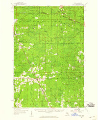 1958 Rock1959 Print · USGSUpper Peninsula timberlands and small rail-side settlements are captured here in the late fifties, just as forest management patterns were maturing. Researchers can trace family roots through locations like Rock, McFarland, and Hillview Cem along the Chicago and Northwestern line.3 unique versions available
 - 1958 Map of Marquette, 1968 Print
 1958 Marquette1968 Print · USGSThe Upper Peninsula’s central corridor is captured here in the mid-twentieth century as mining and timber industries thrived alongside new military installations. Genealogists and historians can trace the rail lines of the Soo Line Railroad through settlements like Gwinn, Turin, and Chatham.2 unique versions available
End of results
Showing maps 1-11 of 11
Top cities near Ewing Township
Frequently asked questions
- What are the different types of historical maps available for Ewing Township?
- What is the oldest map of Ewing Township?
- Where can I purchase historical maps of Ewing Township for my home or office?
- Where can I download high-res historical maps of Ewing Township?
- Are there historical topographic maps available for Ewing Township?
- Is there historical aerial imagery available for Ewing Township?
- Where are historical maps of Ewing Township sourced from?