1980s Maps of Powell Township, Michigan
Explore 11 historic maps of Powell Township from the 1980s. These maps offer a rare glimpse into what life looked like during the 1980s — showing old roads, neighborhoods, homes, and landmarks that have changed or disappeared over time.
Whether you're researching your family's past, planning a metal detecting trip, or studying how Powell Township's landscape evolved across the 1980s, these high-resolution maps are a powerful tool for exploring the history of this region.
- Focus on a specific era: All maps on this page are from the 1980s, giving you a focused view of this time period.
- See what’s changed: Compare century-old streets, trails, and buildings to today's modern landscape using overlays and satellite layers.
- Research with precision: Use these maps for genealogy, historical research, land use analysis, or educational projects.
- View, download, or print: Maps are fully viewable online in high resolution, and can be downloaded or printed for your own records.
Start exploring Powell Township's history through authentic maps from the 1980s. This is your window into the past.
Powell Township, MI maps
(11)- 1984 Map of Ives Hill, 1985 Print
 1984 Ives Hill1985 Print · USGSUpper Michigan's wilderness remains largely untouched in the mid-eighties as shown in this survey of the Huron Mountains. Map collectors and hikers can trace remote landmarks like Ives Hill, Hogback Falls, and the shoreline at Gillet Landing.2 unique versions available
 - 1984 Map of Glovers Corner, 1985 Print
 1984 Glovers Corner1985 Print · USGSThe Upper Peninsula shoreline during the early 1980s reveals a landscape of protected forests and isolated outposts. Trace the winding paths of the Huron River and Little Huron River past landmarks like Bald Mountain and Glovers Corner.
 - 1984 Map of Howe Lake, 1985 Print
 1984 Howe Lake1985 Print · USGSThe Marquette shoreline and its outlying archipelago come into focus in this mid-1980s study of the Michigan coast. Researchers can trace historic maritime landmarks like Huron Island L.H. and the rugged interior peaks of Mount Ida and the Huron Mountains.
 - 1984 Map of McComb Corner, 1985 Print
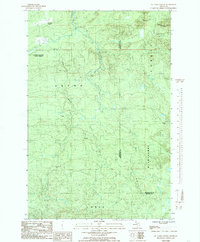 1984 McComb Corner1985 Print · USGSUpper Peninsula wilderness at the edge of Baraga and Marquette Counties is captured here in the early 1980s. Genealogists and local historians can trace remote outposts like McComb Corner and Erickson Camp, or follow the path of the Old RR Grade through the forest.
 - 1985 Map of Mountain Lake
 1985 Mountain Lake1985 Print · USGSUpper Peninsula wilderness and high peaks define this 1980s survey of the Marquette and Baraga county line. Researchers can trace the drainage of the Salmon Trout River and locate remote landmarks like Dodge City, Mountain Lake, and Mummy Mountain.
 - 1985 Map of Huron Mountain
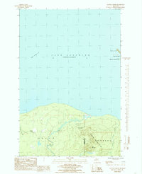
 1985 Huron Mountain1985 Print · USGSThe Lake Superior shoreline in Marquette County is captured in the mid-1980s, documenting a landscape defined by water and woods. Local historians can trace the paths of the Pine River and identify landmarks like Huron Mountain and Conway Lake.
 - 1985 Map of Granite Point
 1985 Granite Point1985 Print · USGSThe Marquette County coastline in the mid-eighties remains a pristine stretch of woods and water. Trace the shoreline from Granite Point through the Escanaba River State Forest to see how this rugged landscape appeared decades ago.
 - 1985 Map of Big Bay
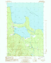 1985 Big Bay1985 Print · USGSMarquette County's northern coast is documented here in the mid-1980s, centered on the settlement of Big Bay and its lumbering roots. Researchers can trace the Old RR Grade through the Escanaba River State Forest or locate family sites near Homeier and Burns Landing.
 - 1985 Map of Buckroe
 1985 Buckroe1985 Print · USGSMarquette County's rugged Lake Superior coastline is captured here in the mid-1980s, showcasing a landscape of state forests and quiet river outlets. You can trace the Old Railroad Grade past Garlic Mountain or locate the old Sawmill and the settlement at Buckroe.
 - 1985 Map of Marquette
 1985 Marquette1985 Print · USGSThe iron mining country of Michigan's Upper Peninsula is shown here during the mid-1980s as industrial transport networks connected the interior to the coast. Researchers can trace historic rail lines like the Soo Line and Ls&I or locate local landmarks like Holy Cross Cem and Northern Michigan University.3 unique versions available
 - 1985 Map of Negaunee NW
 1985 Negaunee NW1985 Print · USGSThe backcountry of Marquette County is documented in the mid-eighties, showing the transition between the Escanaba River State Forest and the surrounding townships. Trace the paths of the Yellow Dog River and discover remote landmarks like Hairpin Curve and Third Bass Lake.2 unique versions available
End of results
Showing maps 1-11 of 11
Top cities near Powell Township
Top neighborhoods of Powell Township
- Alder historical maps
- Birch historical maps
- Burns Landing historical maps
- Gillet Landing historical maps
- Homeier historical maps
- Halfway Village historical maps
See more
Frequently asked questions
- What are the different types of historical maps available for Powell Township?
- What is the oldest map of Powell Township?
- Where can I purchase historical maps of Powell Township for my home or office?
- Where can I download high-res historical maps of Powell Township?
- Are there historical topographic maps available for Powell Township?
- Is there historical aerial imagery available for Powell Township?
- Where are historical maps of Powell Township sourced from?