Old Maps of Midland County, Michigan
Explore 112 old maps of Midland County, spanning from 1917 to today. These high-resolution historic maps reveal how streets, neighborhoods, landmarks, and natural features evolved over time — perfect for genealogy, metal detecting, research, and local history exploration.
What you can do with these maps:
- See how Midland County changed over time: Compare historical maps to modern-day views to trace roads, homesites, rail lines & more.
- View detailed metadata: Each map includes creators, publishers, year, scale, and archive source.
- Overlay maps with satellite & LiDAR: Visualize the past alongside modern tools to explore terrain & human change.
- Trusted historical sources: Maps sourced from the USGS, Library of Congress, and other archives.
- Access maps your way: View online, download high-res files, or order prints for personal or research use.
Start exploring old maps of Midland County to uncover forgotten places, hidden landmarks, and the deep history beneath your feet.
Midland County, MI maps
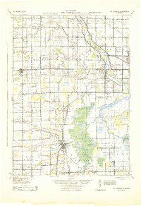
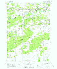
(112)- 1917 Map of St. Charles
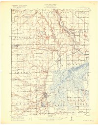 1917 St. Charles1917 Print · USGSThe Saginaw Valley coal and rail corridor comes into focus here during the early twentieth century. Genealogists and researchers can trace family lands near dozens of local landmarks like No 3 Mine, Oakwood Cemetery, and the Prairie Farm.4 unique versions available
 - 1930 Map of Shepherd
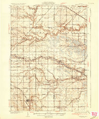
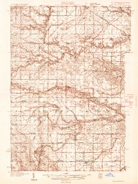 1930 Shepherd1930 Print · USGSIsabella and Midland counties are shown during the 1930s oil boom, centered on the infrastructure around Oil City. Genealogists and researchers can trace family lands near dozens of rural schoolhouses like McNelly Sch or visit the Coleman Cem.3 unique versions available
 - 1934 Map of Sanford, 1965 Print
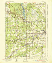
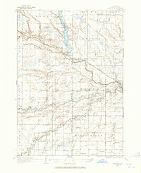 1934 Sanford1965 Print · USGSMidland County's river valleys and township lines are preserved here in the mid-thirties, showing the early infrastructure of the Tittabawassee basin. Researchers can trace rural school districts like St Elmo Sch and historic river crossings at Knight Landing.
 - 1934 Map of Merrill, 1987 Print
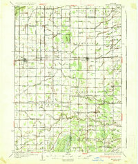
 1934 Merrill1987 Print · USGSThe Gratiot and Saginaw county line in the mid-1930s is a landscape of established farmsteads and rural school districts. Genealogists can trace family roots through numerous local landmarks like Sacred Heart Cem and schools such as Cozy Corner Sch and Sunnylawn Sch.
 - 1935 Map of Alma, 1959 Print
 1935 Alma1959 Print · USGSGratiot County thrived as a rail-and-river hub in the mid-thirties, centered on the growing industrial and agricultural corridor between Alma and St Louis. Genealogists and historians can trace dozens of rural schoolhouses and family landmarks, from Jack Day Sch to the County Home near Ithaca.2 unique versions available
 - 1936 Map of Shepherd
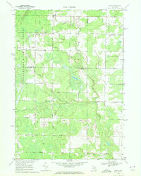
 1936 Shepherd1936 Print · USGSCentral Michigan’s rural landscape comes alive in this mid-1930s survey of the Isabella and Midland county line. Genealogists can locate dozens of country schoolhouses like Polish Sch and early churches such as Geneva Hope Ch near the village of Shepherd.2 unique versions available
 - 1936 Map of Sanford
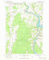
 1936 Sanford1936 Print · USGSMidland County in the mid-1930s reveals a landscape of river-driven commerce and emerging conservation. Researchers can trace the Pere Marquette rail line or locate vanished local hubs like Dittmar, Dice, and Francis Grove.2 unique versions available
 - 1937 Map of Merrill
 1937 Merrill1937 Print · USGSThe borderlands of Saginaw and Gratiot Counties are captured here in the 1930s, showing a landscape defined by rail and rural drainage. Genealogists can trace family connections through dozens of local schools and landmarks like Sacred Heart Cem, Merrill, and the Pere Marquette line.
 - 1938 Map of Alma
 1938 Alma1938 Print · USGSThe Gratiot County landscape at the height of the New Deal era reveals a dense network of country schools and rail lines. Genealogists can trace family roots through numerous named sites like Jack Day Sch, Pine Grove Cem, and the County Home.2 unique versions available
 - 1943 Map of St. Charles
 1943 St. Charles1943 Print · USGSMid-century Saginaw County emerges here as a hub of river-and-rail industry during the height of the coal era. Genealogists and historians can trace family-named schools and early settlements from St. Charles to Hemlock, alongside No 3 Mine.
 - 1954 Map of Midland, 1967 Print
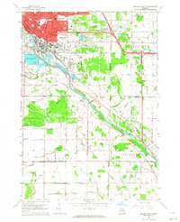
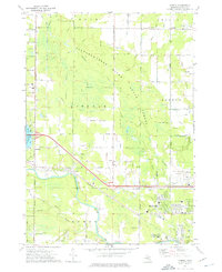
 1954 Midland1967 Print · USGSMid-Michigan at the peak of the post-war era shows a landscape balancing industrial growth in Midland with the deep timberlands of the Manistee National Forest. Researchers can trace the legacy of the timber and rail era along the Pennsylvania RR or find family roots in river towns like Chesaning and Big Rapids.4 unique versions available
 - 1958 Map of Midland
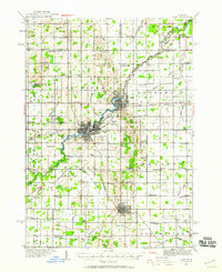
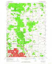
 1958 Midland1958 Print · USGSCentral Michigan in the late fifties is captured here during a period of transition for its university towns and industrial hubs. Genealogists and researchers can trace family lines through old rail-stop towns like Breckenridge and Chesaning or locate property near the Muskegon River and Prairie Farm.
 - 1959 Map of Midland
 1959 Midland1959 Print · USGSMid-century Michigan comes alive in this survey of the central Lower Peninsula, from the streets of Grand Rapids to the Houghton Lake timberlands. Genealogists and rail fans can trace the Ann Arbor RR and Chesapeake and Ohio RR through towns like Big Rapids and Mount Pleasant.
 - 1962 Map of Midland South, 1964 Print
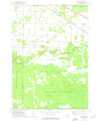
 1962 Midland South1964 Print · USGSMidland and the Tittabawassee River valley are caught in a period of mid-century industrial and suburban growth. Researchers can trace the footprints of smaller communities like Poseyville and Mapleton or locate the Pine Grove Cem and Church of God.4 unique versions available
 - 1962 Map of Midland North, 1964 Print
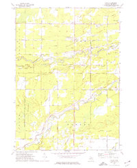
 1962 Midland North1964 Print · USGSMidland and its northern rural townships are captured here in the early sixties as suburban neighborhoods began to meet the industrial salt-brine fields. Genealogists can locate many local landmarks, from Calvary Cem to country schools like Cassidy Sch and Leiphart Sch.2 unique versions available
 - 1966 Map of Midland
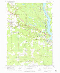
 1966 Midland1966 Print · USGSCentral Michigan in the mid-1960s shows a landscape of growing manufacturing hubs and active resource extraction. Genealogists and historians can trace the rail corridors of the Grand Trunk Western or locate family-named landmarks near Oil wells and the Muskegon River.
 - 1969 Map of Coleman, 1972 Print
 1969 Coleman1972 Print · USGSMidland and Isabella counties show a landscape of energy and agriculture during the late sixties. Trace the old industrial footprints of the West Beaverton Oil Field and the Chesapeake and Ohio rail lines near Coleman.2 unique versions available
 - 1969 Map of Hope, 1972 Print
 1969 Hope1972 Print · USGSMidland County shoreline communities and inland farmsteads are documented here in the late sixties as lakeside development expanded. Researchers can trace family roots at New Hope Cem, locate the Hillside Sch, or follow the Old Railroad Grade through the woods.
 - 1969 Map of Edenville, 1972 Print
 1969 Edenville1972 Print · USGSMid-Michigan lake country is defined by the convergence of two major rivers in the late 1960s. Researchers can trace the development of Edenville, find local landmarks like Robinson Airfield, and locate family sites near St Anne Ch.2 unique versions available
 - 1969 Map of Estey, 1972 Print
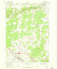
 1969 Estey1972 Print · USGSThe Michigan backcountry at the junction of Gladwin and Midland counties comes alive in this late-sixties survey. Genealogists and local historians can trace family-named roads and landmarks like Mills Sch, Bethel Ch, and an Old Railroad Grade.
 - 1973 Map of Sanford, 1976 Print
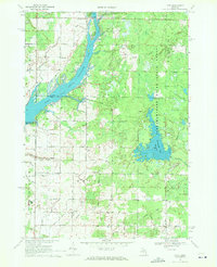
 1973 Sanford1976 Print · USGSMidland County's river valleys and oil fields are captured here in the early 1970s, as industry and recreation converge around the Sanford Lake reservoir. Researchers can trace historic family burial sites at Community Cem and Township Cem or follow the path of the Chesapeake and Ohio rail line.
 - 1973 Map of Gordonville, 1976 Print
 1973 Gordonville1976 Print · USGSMidland County in the early 1970s shows a landscape of river confluences and industrial brine extraction. Genealogists can trace family names at Wayne Cem and Poseyville Cem or locate community hubs like Dice Corners and the Townhall in Mount Haley.
 - 1973 Map of Averill, 1976 Print
 1973 Averill1976 Print · USGSMid-century Midland County is shown during a period of expanding educational and aviation infrastructure. Researchers can trace the path of the Chesapeake and Ohio railroad through Averill or locate family sites at Bombay Cem and Larkin Cem.
 - 1973 Map of Alamando, 1976 Print
 1973 Alamando1976 Print · USGSMidland and Isabella County at the start of the 1970s show a landscape shaped by state forests and the winding Salt River. Genealogists can locate family landmarks like the Township Cem, Geneva Hope Ch, and the rural community of Alamando.
 - 1973 Map of Floyd, 1976 Print
 1973 Floyd1976 Print · USGSMidland County's industrial and woodland character is on full display in the early seventies as the brine and oil industries work alongside the river valleys. Researchers can trace rural lineages through the Township Cemetery and old settlements like Floyd and St Elmo.
Showing maps 1-25 of 112
Top cities of Midland County
Frequently asked questions
- What are the different types of historical maps available for Midland County?
- What is the oldest map of Midland County?
- Where can I purchase historical maps of Midland County for my home or office?
- Where can I download high-res historical maps of Midland County?
- Are there historical topographic maps available for Midland County?
- Is there historical aerial imagery available for Midland County?
- Where are historical maps of Midland County sourced from?