1970s Maps of Midland County, Michigan
Explore 10 historic maps of Midland County from the 1970s. These maps offer a rare glimpse into what life looked like during the 1970s — showing old roads, neighborhoods, homes, and landmarks that have changed or disappeared over time.
Whether you're researching your family's past, planning a metal detecting trip, or studying how Midland County's landscape evolved across the 1970s, these high-resolution maps are a powerful tool for exploring the history of this region.
- Focus on a specific era: All maps on this page are from the 1970s, giving you a focused view of this time period.
- See what’s changed: Compare century-old streets, trails, and buildings to today's modern landscape using overlays and satellite layers.
- Research with precision: Use these maps for genealogy, historical research, land use analysis, or educational projects.
- View, download, or print: Maps are fully viewable online in high resolution, and can be downloaded or printed for your own records.
Start exploring Midland County's history through authentic maps from the 1970s. This is your window into the past.
Midland County, MI maps
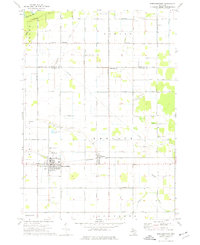
(10)- 1973 Map of Sanford, 1976 Print
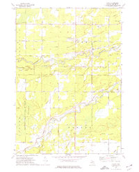
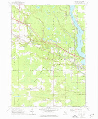 1973 Sanford1976 Print · USGSMidland County's river valleys and oil fields are captured here in the early 1970s, as industry and recreation converge around the Sanford Lake reservoir. Researchers can trace historic family burial sites at Community Cem and Township Cem or follow the path of the Chesapeake and Ohio rail line.
 - 1973 Map of Gordonville, 1976 Print
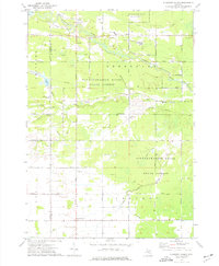
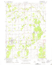
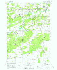 1973 Gordonville1976 Print · USGSMidland County in the early 1970s shows a landscape of river confluences and industrial brine extraction. Genealogists can trace family names at Wayne Cem and Poseyville Cem or locate community hubs like Dice Corners and the Townhall in Mount Haley.
 - 1973 Map of Averill, 1976 Print
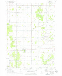
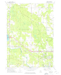 1973 Averill1976 Print · USGSMid-century Midland County is shown during a period of expanding educational and aviation infrastructure. Researchers can trace the path of the Chesapeake and Ohio railroad through Averill or locate family sites at Bombay Cem and Larkin Cem.
 - 1973 Map of Alamando, 1976 Print
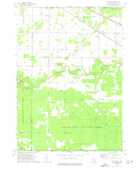 1973 Alamando1976 Print · USGSMidland and Isabella County at the start of the 1970s show a landscape shaped by state forests and the winding Salt River. Genealogists can locate family landmarks like the Township Cem, Geneva Hope Ch, and the rural community of Alamando.
 - 1973 Map of Floyd, 1976 Print
 1973 Floyd1976 Print · USGSMidland County's industrial and woodland character is on full display in the early seventies as the brine and oil industries work alongside the river valleys. Researchers can trace rural lineages through the Township Cemetery and old settlements like Floyd and St Elmo.
 - 1973 Map of Pleasant Valley, 1976 Print
 1973 Pleasant Valley1976 Print · USGSMidland and Isabella counties in the early 1970s reveal an active landscape of energy production and rural community life. Trace the development of Oil City and family landmarks like Kelly Cem or the Martin Luther Institute.
 - 1973 Map of Merrill, 1977 Print
 1973 Merrill1977 Print · USGSMerrill and its surrounding townships are shown in the early seventies as a thriving agricultural and industrial landscape. Genealogists and historians can trace family locations along O'Hara Road, locate the Merrill Ch, or find industrial sites like the Brine Well.
 - 1973 Map of St. Louis, 1977 Print
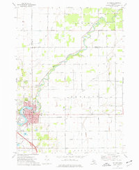 1973 St. Louis1977 Print · USGSMid-century St. Louis and the surrounding farm country are captured here during a period of steady industrial and civic activity. Genealogists and local historians can trace family locations near the Bethany Indian Cem, Oak Grove Cemetery, or the numerous local schools like Westgate Sch.
 - 1973 Map of Breckenridge, 1977 Print
 1973 Breckenridge1977 Print · USGSBreckenridge and Wheeler are shown in detail during the early 1970s, as the local economy balanced farming with oil and rail transit. Genealogists and researchers can locate Rose Lawn Cem, Migrant Workers Camp, and the Porter Oil Field.
 - 1975 Map of Hemlock, 1978 Print
 1975 Hemlock1978 Print · USGSSaginaw County's agricultural and industrial landscape is captured here in the mid-seventies, centered on the village of Hemlock. Genealogists and historians can trace numerous family-named roads, several Brine Wells, and local landmarks like St Johns Cem and the Sonefeld Landing Strip.
End of results
Showing maps 1-10 of 10
Top cities of Midland County
Frequently asked questions
- What are the different types of historical maps available for Midland County?
- What is the oldest map of Midland County?
- Where can I purchase historical maps of Midland County for my home or office?
- Where can I download high-res historical maps of Midland County?
- Are there historical topographic maps available for Midland County?
- Is there historical aerial imagery available for Midland County?
- Where are historical maps of Midland County sourced from?