1930s Maps of Midland County, Michigan
Explore 8 historic maps of Midland County from the 1930s. These maps offer a rare glimpse into what life looked like during the 1930s — showing old roads, neighborhoods, homes, and landmarks that have changed or disappeared over time.
Whether you're researching your family's past, planning a metal detecting trip, or studying how Midland County's landscape evolved across the 1930s, these high-resolution maps are a powerful tool for exploring the history of this region.
- Focus on a specific era: All maps on this page are from the 1930s, giving you a focused view of this time period.
- See what’s changed: Compare century-old streets, trails, and buildings to today's modern landscape using overlays and satellite layers.
- Research with precision: Use these maps for genealogy, historical research, land use analysis, or educational projects.
- View, download, or print: Maps are fully viewable online in high resolution, and can be downloaded or printed for your own records.
Start exploring Midland County's history through authentic maps from the 1930s. This is your window into the past.
Midland County, MI maps
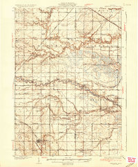
(8)- 1930 Map of Shepherd
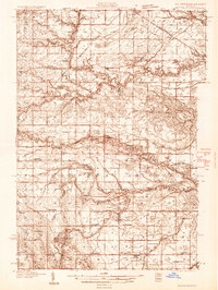 1930 Shepherd1930 Print · USGSIsabella and Midland counties are shown during the 1930s oil boom, centered on the infrastructure around Oil City. Genealogists and researchers can trace family lands near dozens of rural schoolhouses like McNelly Sch or visit the Coleman Cem.3 unique versions available
 - 1934 Map of Sanford, 1965 Print
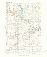 1934 Sanford1965 Print · USGSMidland County's river valleys and township lines are preserved here in the mid-thirties, showing the early infrastructure of the Tittabawassee basin. Researchers can trace rural school districts like St Elmo Sch and historic river crossings at Knight Landing.
 - 1934 Map of Merrill, 1987 Print
 1934 Merrill1987 Print · USGSThe Gratiot and Saginaw county line in the mid-1930s is a landscape of established farmsteads and rural school districts. Genealogists can trace family roots through numerous local landmarks like Sacred Heart Cem and schools such as Cozy Corner Sch and Sunnylawn Sch.
 - 1935 Map of Alma, 1959 Print
 1935 Alma1959 Print · USGSGratiot County thrived as a rail-and-river hub in the mid-thirties, centered on the growing industrial and agricultural corridor between Alma and St Louis. Genealogists and historians can trace dozens of rural schoolhouses and family landmarks, from Jack Day Sch to the County Home near Ithaca.2 unique versions available
 - 1936 Map of Shepherd
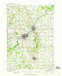
 1936 Shepherd1936 Print · USGSCentral Michigan’s rural landscape comes alive in this mid-1930s survey of the Isabella and Midland county line. Genealogists can locate dozens of country schoolhouses like Polish Sch and early churches such as Geneva Hope Ch near the village of Shepherd.2 unique versions available
 - 1936 Map of Sanford
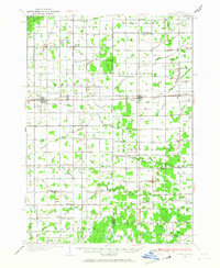
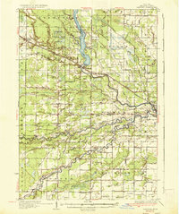 1936 Sanford1936 Print · USGSMidland County in the mid-1930s reveals a landscape of river-driven commerce and emerging conservation. Researchers can trace the Pere Marquette rail line or locate vanished local hubs like Dittmar, Dice, and Francis Grove.2 unique versions available
 - 1937 Map of Merrill
 1937 Merrill1937 Print · USGSThe borderlands of Saginaw and Gratiot Counties are captured here in the 1930s, showing a landscape defined by rail and rural drainage. Genealogists can trace family connections through dozens of local schools and landmarks like Sacred Heart Cem, Merrill, and the Pere Marquette line.
 - 1938 Map of Alma
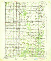
 1938 Alma1938 Print · USGSThe Gratiot County landscape at the height of the New Deal era reveals a dense network of country schools and rail lines. Genealogists can trace family roots through numerous named sites like Jack Day Sch, Pine Grove Cem, and the County Home.2 unique versions available
End of results
Showing maps 1-8 of 8
Top cities of Midland County
Frequently asked questions
- What are the different types of historical maps available for Midland County?
- What is the oldest map of Midland County?
- Where can I purchase historical maps of Midland County for my home or office?
- Where can I download high-res historical maps of Midland County?
- Are there historical topographic maps available for Midland County?
- Is there historical aerial imagery available for Midland County?
- Where are historical maps of Midland County sourced from?