1960s Maps of Midland County, Michigan
Explore 7 historic maps of Midland County from the 1960s. These maps offer a rare glimpse into what life looked like during the 1960s — showing old roads, neighborhoods, homes, and landmarks that have changed or disappeared over time.
Whether you're researching your family's past, planning a metal detecting trip, or studying how Midland County's landscape evolved across the 1960s, these high-resolution maps are a powerful tool for exploring the history of this region.
- Focus on a specific era: All maps on this page are from the 1960s, giving you a focused view of this time period.
- See what’s changed: Compare century-old streets, trails, and buildings to today's modern landscape using overlays and satellite layers.
- Research with precision: Use these maps for genealogy, historical research, land use analysis, or educational projects.
- View, download, or print: Maps are fully viewable online in high resolution, and can be downloaded or printed for your own records.
Start exploring Midland County's history through authentic maps from the 1960s. This is your window into the past.
Midland County, MI maps
(7)- 1962 Map of Midland South, 1964 Print
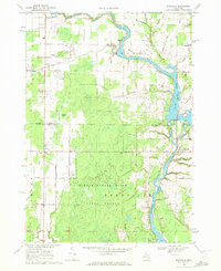
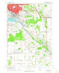 1962 Midland South1964 Print · USGSMidland and the Tittabawassee River valley are caught in a period of mid-century industrial and suburban growth. Researchers can trace the footprints of smaller communities like Poseyville and Mapleton or locate the Pine Grove Cem and Church of God.4 unique versions available
 - 1962 Map of Midland North, 1964 Print
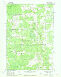
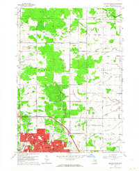 1962 Midland North1964 Print · USGSMidland and its northern rural townships are captured here in the early sixties as suburban neighborhoods began to meet the industrial salt-brine fields. Genealogists can locate many local landmarks, from Calvary Cem to country schools like Cassidy Sch and Leiphart Sch.2 unique versions available
 - 1966 Map of Midland
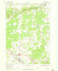
 1966 Midland1966 Print · USGSCentral Michigan in the mid-1960s shows a landscape of growing manufacturing hubs and active resource extraction. Genealogists and historians can trace the rail corridors of the Grand Trunk Western or locate family-named landmarks near Oil wells and the Muskegon River.
 - 1969 Map of Coleman, 1972 Print
 1969 Coleman1972 Print · USGSMidland and Isabella counties show a landscape of energy and agriculture during the late sixties. Trace the old industrial footprints of the West Beaverton Oil Field and the Chesapeake and Ohio rail lines near Coleman.2 unique versions available
 - 1969 Map of Hope, 1972 Print
 1969 Hope1972 Print · USGSMidland County shoreline communities and inland farmsteads are documented here in the late sixties as lakeside development expanded. Researchers can trace family roots at New Hope Cem, locate the Hillside Sch, or follow the Old Railroad Grade through the woods.
 - 1969 Map of Edenville, 1972 Print
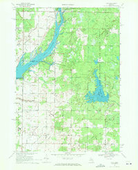
 1969 Edenville1972 Print · USGSMid-Michigan lake country is defined by the convergence of two major rivers in the late 1960s. Researchers can trace the development of Edenville, find local landmarks like Robinson Airfield, and locate family sites near St Anne Ch.2 unique versions available
 - 1969 Map of Estey, 1972 Print
 1969 Estey1972 Print · USGSThe Michigan backcountry at the junction of Gladwin and Midland counties comes alive in this late-sixties survey. Genealogists and local historians can trace family-named roads and landmarks like Mills Sch, Bethel Ch, and an Old Railroad Grade.
End of results
Showing maps 1-7 of 7
Top cities of Midland County
Frequently asked questions
- What are the different types of historical maps available for Midland County?
- What is the oldest map of Midland County?
- Where can I purchase historical maps of Midland County for my home or office?
- Where can I download high-res historical maps of Midland County?
- Are there historical topographic maps available for Midland County?
- Is there historical aerial imagery available for Midland County?
- Where are historical maps of Midland County sourced from?