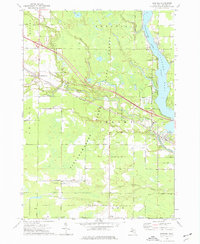
1973 Map of Sanford
USGS Topo · Published 1976About this map
The Tittabawassee River corridor defines this Midland County landscape, flowing south through Sanford Lake into the heart of Sanford. The area is a mix of managed woodlands and industry, evidenced by the large State Forest blocks and an active Oil Field near North Bradley. Significant 1970s infrastructure includes the powerplant at the Sanford dam and the Chesapeake and Ohio railroad cutting across the terrain. Local history and genealogy are well-preserved through several landmarks, such as the Sanford Sch, Township Cem, and Geneva Cem. Small settlements like Francis Grove and Olson dot the rural road network, while recreational areas like the Black Creek Forest Campground and Veterans Memorial Park hug the water's edge.
Find a feature on this map
53 named features on this map. Tap any name to fly to it.
Don’t see what you’re looking for? This feature index may not catch every label — zoom into the map to look around manually.
Map Details
Editions of this 1973 Sanford Map
This is the sole edition of this map. No revisions or reprints were ever made.
Other maps of this area

1930 · Shepherd
USGS Topo · 1:48,000

1934 · Sanford
USGS Topo · 1:62,500

1936 · Shepherd
USGS Topo · 1:62,500

1936 · Sanford
USGS Topo · 1:62,500

1954 · Midland
USGS Topo · 1:250,000

1958 · Midland
USGS Topo · 1:250,000

1959 · Midland
USGS Topo · 1:250,000

1966 · Midland
USGS Topo · 1:250,000

1969 · Coleman
USGS Topo · 1:24,000
1969 · Hope
USGS Topo · 1:24,000