1940s Maps of Farmington, Michigan
Explore 2 historic maps of Farmington from the 1940s. These maps offer a rare glimpse into what life looked like during the 1940s — showing old roads, neighborhoods, homes, and landmarks that have changed or disappeared over time.
Whether you're researching your family's past, planning a metal detecting trip, or studying how Farmington's landscape evolved across the 1940s, these high-resolution maps are a powerful tool for exploring the history of this region.
- Focus on a specific era: All maps on this page are from the 1940s, giving you a focused view of this time period.
- See what’s changed: Compare century-old streets, trails, and buildings to today's modern landscape using overlays and satellite layers.
- Research with precision: Use these maps for genealogy, historical research, land use analysis, or educational projects.
- View, download, or print: Maps are fully viewable online in high resolution, and can be downloaded or printed for your own records.
Start exploring Farmington's history through authentic maps from the 1940s. This is your window into the past.
Farmington, MI maps
(2)- 1942 Map of Redford
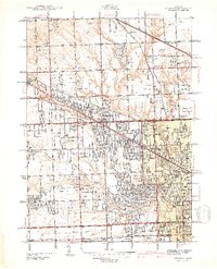 1942 Redford1942 Print · USGSNorthwest of Detroit during the early war years, this survey captures the transition from township farmsteads to suburban hubs. Trace family roots and local landmarks through sites like the Redford PO, Burns Airport, and Grand Lawn Cem.2 unique versions available
 - 1945 Map of Northville
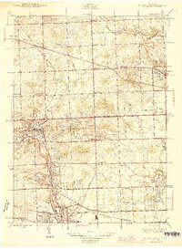 1945 Northville1945 Print · USGSThe border of Wayne and Oakland counties in the mid-1940s reveals a landscape of expanding townships and established institutions. Genealogists and historians can trace family locations near Glen Eden Cem, Waterford Sch, and the Pere Marquette rail line.2 unique versions available
End of results
Showing maps 1-2 of 2
Top cities near Farmington
- Detroit historical maps
- Canton Charter Township historical maps
- Canton Township historical maps
- Livonia historical maps
- Dearborn historical maps
- Troy historical maps
See more
Top neighborhoods of Farmington
Frequently asked questions
- What are the different types of historical maps available for Farmington?
- What is the oldest map of Farmington?
- Where can I purchase historical maps of Farmington for my home or office?
- Where can I download high-res historical maps of Farmington?
- Are there historical topographic maps available for Farmington?
- Is there historical aerial imagery available for Farmington?
- Where are historical maps of Farmington sourced from?