1960s Maps of Pontiac, Michigan
Explore 6 historic maps of Pontiac from the 1960s. These maps offer a rare glimpse into what life looked like during the 1960s — showing old roads, neighborhoods, homes, and landmarks that have changed or disappeared over time.
Whether you're researching your family's past, planning a metal detecting trip, or studying how Pontiac's landscape evolved across the 1960s, these high-resolution maps are a powerful tool for exploring the history of this region.
- Focus on a specific era: All maps on this page are from the 1960s, giving you a focused view of this time period.
- See what’s changed: Compare century-old streets, trails, and buildings to today's modern landscape using overlays and satellite layers.
- Research with precision: Use these maps for genealogy, historical research, land use analysis, or educational projects.
- View, download, or print: Maps are fully viewable online in high resolution, and can be downloaded or printed for your own records.
Start exploring Pontiac's history through authentic maps from the 1960s. This is your window into the past.
Pontiac, MI maps
(6)- 1961 Map of Detroit, 1973 Print
 1961 Detroit1973 Print · USGSThe international border between Michigan and Ontario was a bustling industrial corridor in the early sixties. Researchers can trace the transit networks and riverfront infrastructure connecting Detroit to Windsor via the Detroit-Windsor Tunnel and major air hubs like Willow Run Airport.2 unique versions available
 - 1965 Map of Detroit
 1965 Detroit1965 Print · USGSThe industrial corridor between Michigan and Ontario is captured here at mid-century, showing the dense rail and river networks of the Great Lakes. Local historians can trace the paths of the Grand Trunk Western RR and locate key landmarks like Selfridge Air Force Base and Grosse Ile.
 - 1968 Map of Pontiac South, 1971 Print
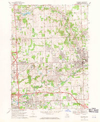
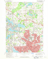
 1968 Pontiac South1971 Print · USGSOakland County's lake district and the growing suburbs of Detroit are captured here in the late sixties. Trace family roots and local development near Cass Lake, Franklin, and the grounds of Cranbrook Sch.3 unique versions available
 - 1968 Map of Rochester, 1971 Print
 1968 Rochester1971 Print · USGSRochester and its surroundings were transforming during the late sixties as suburban campuses and modern infrastructure met established rail lines. Genealogists and local historians can trace family roots at Mt Avon Cemetery or study the early campuses of Oakland University and Michigan Christian College.5 unique versions available
 - 1968 Map of Birmingham, 1971 Print
 1968 Birmingham1971 Print · USGSOakland County's suburban expansion is in full view during the late sixties as residential neighborhoods fill the gaps between historic village centers. Genealogists and local historians can trace the footprint of Birmingham and Royal Oak, locating old landmarks like Berz Airport and White Chapel Cemetery.4 unique versions available
 - 1968 Map of Pontiac North, 1971 Print
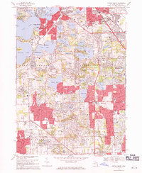
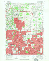
 1968 Pontiac North1971 Print · USGSOakland County's northern expansion is clear in the late sixties as suburban development meets the lake country. Genealogists and historians can trace the grounds of the Pontiac State Hospital, find family plots in Oak Hill Cemetery, or locate the many local schools like Bagley Sch.4 unique versions available
End of results
Showing maps 1-6 of 6
Top cities near Pontiac
- Detroit historical maps
- Sterling Heights historical maps
- Warren historical maps
- Livonia historical maps
- Troy historical maps
- Farmington Hills historical maps
See more
Frequently asked questions
- What are the different types of historical maps available for Pontiac?
- What is the oldest map of Pontiac?
- Where can I purchase historical maps of Pontiac for my home or office?
- Where can I download high-res historical maps of Pontiac?
- Are there historical topographic maps available for Pontiac?
- Is there historical aerial imagery available for Pontiac?
- Where are historical maps of Pontiac sourced from?