1950s Maps of Pontiac, Michigan
Explore 5 historic maps of Pontiac from the 1950s. These maps offer a rare glimpse into what life looked like during the 1950s — showing old roads, neighborhoods, homes, and landmarks that have changed or disappeared over time.
Whether you're researching your family's past, planning a metal detecting trip, or studying how Pontiac's landscape evolved across the 1950s, these high-resolution maps are a powerful tool for exploring the history of this region.
- Focus on a specific era: All maps on this page are from the 1950s, giving you a focused view of this time period.
- See what’s changed: Compare century-old streets, trails, and buildings to today's modern landscape using overlays and satellite layers.
- Research with precision: Use these maps for genealogy, historical research, land use analysis, or educational projects.
- View, download, or print: Maps are fully viewable online in high resolution, and can be downloaded or printed for your own records.
Start exploring Pontiac's history through authentic maps from the 1950s. This is your window into the past.
Pontiac, MI maps
(5)- 1952 Map of Pontiac North, 1954 Print
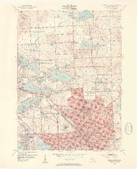 1952 Pontiac North1954 Print · USGSMid-century Oakland County is captured here during a period of rapid suburban growth north of Detroit. Family historians can locate specific neighborhood developments near Lake Oakland or trace ancestors through Oakland Cem and Perry-Mount Park Cemetery.2 unique versions available
 - 1952 Map of Rochester, 1954 Print
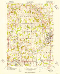 1952 Rochester1954 Print · USGSOakland County was undergoing a period of rapid suburbanization in the early fifties as the rural townships of Avon and Oakland began to fill in. Local historians can trace family roots through numerous country schools and churches, including Five Points Ch, Howarth Sch, and The Haven Sanitarium.3 unique versions available
 - 1952 Map of Birmingham, 1954 Print
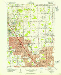 1952 Birmingham1954 Print · USGSThe northern Detroit suburbs are shown here during their early 1950s growth, centering on the rail and road corridors of Oakland County. Genealogists can trace family landmarks like the Leonard Sch, Log Cabin Sch, and the Shrine of the Little Flower.
 - 1952 Map of Pontiac South, 1954 Print
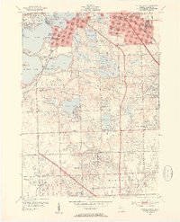 1952 Pontiac South1954 Print · USGSOakland County's lake country in the early fifties shows a transition from rural estates to suburban neighborhoods. Genealogists and historians can trace local roots through sites like Franklin Cem, Vaughn Cem, and the Cranbrook Sch campus.2 unique versions available
 - 1954 Map of Detroit
 1954 Detroit1954 Print · USGSThe Detroit metro and its Ontario neighbors are shown at the height of the mid-century industrial era, just as the suburbs were rapidly expanding. Researchers can trace the massive rail networks of the Wabash Railroad or locate landmarks like Grosse Ile and Selfridge Air Force Base.
End of results
Showing maps 1-5 of 5
Top cities near Pontiac
- Detroit historical maps
- Sterling Heights historical maps
- Warren historical maps
- Livonia historical maps
- Troy historical maps
- Farmington Hills historical maps
See more
Frequently asked questions
- What are the different types of historical maps available for Pontiac?
- What is the oldest map of Pontiac?
- Where can I purchase historical maps of Pontiac for my home or office?
- Where can I download high-res historical maps of Pontiac?
- Are there historical topographic maps available for Pontiac?
- Is there historical aerial imagery available for Pontiac?
- Where are historical maps of Pontiac sourced from?