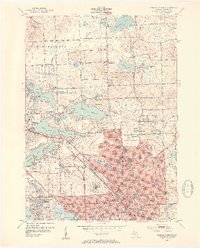
1952 Map of Pontiac North
USGS Topo · Published 1954About this map
The growing city of Pontiac anchors this 1952 culture revision, showing the transition from dense urban development to the glaciated lake country of Waterford and Orion townships. The map captures an era of post-war expansion where residential pockets like Elizabeth Lake Estates and Huron Gardens emerged alongside established institutions such as the Pontiac State Hospital and County Hospital. A striking feature of this landscape is the density of water bodies, including Lake Oakland and Lake Angelus, which shaped the local recreation and residential patterns seen in the Silver Lake Golf Course and Pontiac Country Club.
Find a feature on this map
100 named features on this map. Tap any name to fly to it.
Don’t see what you’re looking for? This feature index may not catch every label — zoom into the map to look around manually.
Map Details
Editions of this 1952 Pontiac North Map
2 editions found
Other maps of this area

1907 · Pontiac
USGS Topo · 1:62,500

1908 · Rochester
USGS Topo · 1:62,500

1936 · Birmingham
USGS Topo · 1:31,680

1936 · Clarkston
USGS Topo · 1:31,680

1936 · Rochester
USGS Topo · 1:31,680

1936 · Walled Lake
USGS Topo · 1:31,680

1936 · Pontiac South
USGS Topo · 1:31,680

1936 · Pontiac North
USGS Topo · 1:31,680

1943 · Clarkston
USGS Topo · 1:24,000

1943 · Pontiac South
USGS Topo · 1:24,000
Featured Places
- Waterford Township, MI
- Pontiac, MI
- Orion Charter Township, MI
- Independence Charter Township, MI
- Auburn Hills, MI