
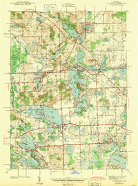
1943 Map of Clarkston
USGS Topo · Published 1943About this map
The Clinton River winds through a dense network of glacial lakes and developing townships in northern Oakland County, reflecting a landscape defined by water and early mid-century transportation. The Grand Trunk Western RR serves as a central artery, connecting established villages like Clarkston and Waterford, while the Pontiac Municipal Airport signals the growing regional infrastructure of the early 1940s. Local life is anchored by social and spiritual landmarks such as St Patricks Ch and numerous rural schools, including the Webster Sch and Dublin Sch.
Find a feature on this map
84 named features on this map. Tap any name to fly to it.
Don’t see what you’re looking for? This feature index may not catch every label — zoom into the map to look around manually.
Map Details
Editions of this 1943 Clarkston Map
2 editions found
Other maps of this area

1907 · Pontiac
USGS Topo · 1:62,500

1909 · Milford
USGS Topo · 1:62,500

1920 · Holly
USGS Topo · 1:62,500

1922 · Holly
USGS Topo · 1:62,500

1936 · Wixom
USGS Topo · 1:31,680

1936 · Highland
USGS Topo · 1:31,680

1936 · Clarkston
USGS Topo · 1:31,680

1936 · Walled Lake
USGS Topo · 1:31,680

1936 · Pontiac South
USGS Topo · 1:31,680

1936 · Pontiac North
USGS Topo · 1:31,680
Featured Places
- Waterford Township, MI
- Independence Charter Township, MI
- White Lake Charter Township, MI
- Springfield Charter Township, MI
- Clarkston, MI