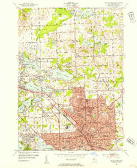
1952 Map of Pontiac North
USGS Topo · Published 1954About this map
The urban core of Pontiac and its sprawling northern lake district are caught in a period of significant post-war expansion. The industrial and institutional character of the city is anchored by the massive Pontiac State Hospital complex and several major healthcare and civic landmarks like the County Home and General Hospital. Transportation is dominated by the Grand Trunk railroad corridor, which carves through the city toward the outlying lakefront communities. To the north, the landscape shifts into a dense network of glacial lakes, including Lake Oakland and Lake Angelus, where residential developments like Elizabeth Lake Estates and Huron Gardens were rapidly filling in. The sheer density of neighborhood schools, from Washington Jr High Sch to Longfellow Sch, illustrates the demographic boom of the early 1950s in Oakland County.
Find a feature on this map
102 named features on this map. Tap any name to fly to it.
Don’t see what you’re looking for? This feature index may not catch every label — zoom into the map to look around manually.
Map Details
Editions of this 1952 Pontiac North Map
2 editions found
Other maps of this area

1907 · Pontiac
USGS Topo · 1:62,500

1908 · Rochester
USGS Topo · 1:62,500

1936 · Birmingham
USGS Topo · 1:31,680

1936 · Clarkston
USGS Topo · 1:31,680

1936 · Rochester
USGS Topo · 1:31,680

1936 · Walled Lake
USGS Topo · 1:31,680

1936 · Pontiac South
USGS Topo · 1:31,680

1936 · Pontiac North
USGS Topo · 1:31,680

1943 · Clarkston
USGS Topo · 1:24,000

1943 · Pontiac South
USGS Topo · 1:24,000
Featured Places
- Waterford Township, MI
- Pontiac, MI
- Orion Charter Township, MI
- Independence Charter Township, MI
- Auburn Hills, MI