1940s Maps of Rochester Hills, Michigan
Explore 4 historic maps of Rochester Hills from the 1940s. These maps offer a rare glimpse into what life looked like during the 1940s — showing old roads, neighborhoods, homes, and landmarks that have changed or disappeared over time.
Whether you're researching your family's past, planning a metal detecting trip, or studying how Rochester Hills's landscape evolved across the 1940s, these high-resolution maps are a powerful tool for exploring the history of this region.
- Focus on a specific era: All maps on this page are from the 1940s, giving you a focused view of this time period.
- See what’s changed: Compare century-old streets, trails, and buildings to today's modern landscape using overlays and satellite layers.
- Research with precision: Use these maps for genealogy, historical research, land use analysis, or educational projects.
- View, download, or print: Maps are fully viewable online in high resolution, and can be downloaded or printed for your own records.
Start exploring Rochester Hills's history through authentic maps from the 1940s. This is your window into the past.
Rochester Hills, MI maps
(4)- 1945 Map of Birmingham
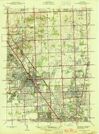 1945 Birmingham1945 Print · USGSOakland County was undergoing a massive suburban transformation in the years following the war. Researchers can trace the early residential grids of Birmingham and Berkley or locate local landmarks like the Log Cabin Sch and St Hugo Ch.
 - 1945 Map of Rochester
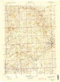 1945 Rochester1945 Print · USGSOakland County was shifting from a quiet rural landscape to a suburban corridor in the mid-1940s. Genealogists can locate family landmarks like Snell Sch, the Oakland Cem, and old settlements like Goodison and Auburn Heights.2 unique versions available
 - 1946 Map of Utica
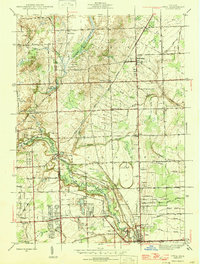 1946 Utica1946 Print · USGSMacomb and Oakland counties are captured here just after the war as the township of Shelby begins its post-war transition. Genealogists and local historians can trace family roots through numerous country schools like Plain Sch and cemeteries such as Prestonville Cem or Stony Creek Cem.2 unique versions available
 - 1946 Map of Warren
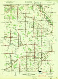 1946 Warren1946 Print · USGSThe Macomb and Oakland county borderlands are shown here in the mid-1940s, capturing a world of rural schools and early suburban aviation. Genealogists can trace family footprints near the Warren Cem, Big Beaver, and rural schoolhouses like Burr Sch.
End of results
Showing maps 1-4 of 4
Top cities near Rochester Hills
- Detroit historical maps
- Sterling Heights historical maps
- Warren historical maps
- Clinton Township historical maps
- Livonia historical maps
- Macomb Township historical maps
See more
Top neighborhoods of Rochester Hills
- Yates historical maps
- Flowing Spring Acres historical maps
- Messmore Farms historical maps
- Pon-Avon Farms historical maps
- Avon Lakes Village historical maps
- Avon Manor Estates historical maps
See more
Frequently asked questions
- What are the different types of historical maps available for Rochester Hills?
- What is the oldest map of Rochester Hills?
- Where can I purchase historical maps of Rochester Hills for my home or office?
- Where can I download high-res historical maps of Rochester Hills?
- Are there historical topographic maps available for Rochester Hills?
- Is there historical aerial imagery available for Rochester Hills?
- Where are historical maps of Rochester Hills sourced from?