1930s Maps of St. Clair Township, Michigan
Explore 5 historic maps of St. Clair Township from the 1930s. These maps offer a rare glimpse into what life looked like during the 1930s — showing old roads, neighborhoods, homes, and landmarks that have changed or disappeared over time.
Whether you're researching your family's past, planning a metal detecting trip, or studying how St. Clair Township's landscape evolved across the 1930s, these high-resolution maps are a powerful tool for exploring the history of this region.
- Focus on a specific era: All maps on this page are from the 1930s, giving you a focused view of this time period.
- See what’s changed: Compare century-old streets, trails, and buildings to today's modern landscape using overlays and satellite layers.
- Research with precision: Use these maps for genealogy, historical research, land use analysis, or educational projects.
- View, download, or print: Maps are fully viewable online in high resolution, and can be downloaded or printed for your own records.
Start exploring St. Clair Township's history through authentic maps from the 1930s. This is your window into the past.
St. Clair Township, MI maps
(5)- 1936 Map of St. Clair
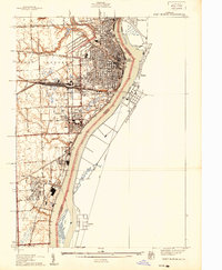
 1936 St. Clair1936 Print · USGSThe Michigan shoreline along the St. Clair River was a bustling corridor of rail and river commerce during the 1930s. Genealogists and local historians can trace early school districts and landmarks like Red Brick Sch, St Marys Ch, and Hillside Cem.
 - 1936 Map of Rattle Run
 1936 Rattle Run1936 Print · USGSSt. Clair County in the mid-thirties remains a landscape of quiet township crossroads and small family farms. Genealogists and local historians can trace the exact locations of many rural schoolhouses like Kennedy Sch and old burial grounds including Balfour Cem and St Marys Cem.
 - 1939 Map of Port Huron
 1939 Port Huron1939 Print · USGSPort Huron and Marysville are shown at the height of their industrial development just before World War II. Local historians can trace the intricate rail network of the Grand Trunk Western and locate neighborhood landmarks like Pine Grove Park and Roosevelt Sch.
 - 1939 Map of St. Clair
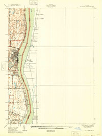 1939 St. Clair1939 Print · USGSThe St. Clair River shoreline in the late 1930s reveals a vibrant international borderland of riverfront towns and rural school districts. Genealogists and local historians can trace family locations near landmarks like the Red Brick Sch, St Marys Cem, and the Port Huron and Detroit rail line.
 - 1939 Map of Smiths Creek
 1939 Smiths Creek1939 Print · USGSSt. Clair County is shown in the late 1930s as a landscape of rural schools and heavy rail lines. Researchers can trace the heritage of vanished school districts and family cemeteries like Caswell Cem and the Canada Settlement Sch alongside the Grand Trunk Western tracks.
End of results
Showing maps 1-5 of 5
Top cities near St. Clair Township
- Chesterfield Township historical maps
- Port Huron historical maps
- New Baltimore historical maps
- Marysville historical maps
- Kimball historical maps
- West Tappan historical maps
See more
Top neighborhoods of St. Clair Township
Frequently asked questions
- What are the different types of historical maps available for St. Clair Township?
- What is the oldest map of St. Clair Township?
- Where can I purchase historical maps of St. Clair Township for my home or office?
- Where can I download high-res historical maps of St. Clair Township?
- Are there historical topographic maps available for St. Clair Township?
- Is there historical aerial imagery available for St. Clair Township?
- Where are historical maps of St. Clair Township sourced from?