1930s Maps of Thompson Township, Michigan
Explore 6 historic maps of Thompson Township from the 1930s. These maps offer a rare glimpse into what life looked like during the 1930s — showing old roads, neighborhoods, homes, and landmarks that have changed or disappeared over time.
Whether you're researching your family's past, planning a metal detecting trip, or studying how Thompson Township's landscape evolved across the 1930s, these high-resolution maps are a powerful tool for exploring the history of this region.
- Focus on a specific era: All maps on this page are from the 1930s, giving you a focused view of this time period.
- See what’s changed: Compare century-old streets, trails, and buildings to today's modern landscape using overlays and satellite layers.
- Research with precision: Use these maps for genealogy, historical research, land use analysis, or educational projects.
- View, download, or print: Maps are fully viewable online in high resolution, and can be downloaded or printed for your own records.
Start exploring Thompson Township's history through authentic maps from the 1930s. This is your window into the past.
Thompson Township, MI maps
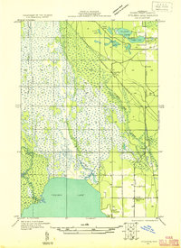
(6)- 1931 Map of Cooks NE
 1931 Cooks NE1931 Print · USGSCoastal Schoolcraft County comes alive in this early 1930s survey of the northern Lake Michigan shoreline. Genealogists and local historians can trace the rail lines of the Manistique Ry and locate family landmarks like Heights Sch and Dufour.
 - 1931 Map of Steuben SE
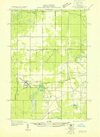
 1931 Steuben SE1931 Print · USGSUpper Peninsula timberlands and wetlands are surveyed here in the early thirties. Genealogists and local researchers can trace the rail stops and rural schools of Schoolcraft County, from Hiawatha Sta to the Maple Grove Sch near Indian Lake.
 - 1931 Map of Steuben SW
 1931 Steuben SW1931 Print · USGSThe Upper Peninsula wilderness in the early 1930s is documented here through a dense network of glacial lakes and river systems. Historians and outdoor researchers can trace the old water routes of the Indian River and locate landmarks like Thunder Lake and Frankes Lake.
 - 1931 Map of Steuben NE
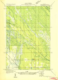 1931 Steuben NE1931 Print · USGSSchoolcraft County in the early thirties reveals a landscape of dense forests and emerging infrastructure within the Hiawatha National Forest Boundary. Researchers can trace the old Manistique and Lake Superior rail line to the Smith Creek Station or locate the rural Hiawatha School No 2.
 - 1931 Map of Cooks NW
 1931 Cooks NW1931 Print · USGSThe Upper Peninsula wilderness around the Delta and Schoolcraft county line comes into focus in the early 1930s. Genealogists and local historians can trace rural life through the Cooks Sch, the Seventh Day Adventist Sch, and the rail stops of Cooks and Elkhorn.
 - 1931 Map of Steuben NW
 1931 Steuben NW1931 Print · USGSThe Upper Peninsula wilderness in the early 1930s is defined here by its intricate network of lakes and the essential Manistique and Lake Superior railroad. You can trace the development of the Steuben settlement or locate historic camps like Jack Pine Lodge and the Woods Club along the Indian River.
End of results
Showing maps 1-6 of 6
Top cities near Thompson Township
Top neighborhoods of Thompson Township
- Minor Beach historical maps
- Richardsons Mill historical maps
- Michiwaukee Shores historical maps
- Sunset Beach historical maps
- Thompson historical maps
Frequently asked questions
- What are the different types of historical maps available for Thompson Township?
- What is the oldest map of Thompson Township?
- Where can I purchase historical maps of Thompson Township for my home or office?
- Where can I download high-res historical maps of Thompson Township?
- Are there historical topographic maps available for Thompson Township?
- Is there historical aerial imagery available for Thompson Township?
- Where are historical maps of Thompson Township sourced from?