1960s Maps of Huron Charter Township, Michigan
Explore 6 historic maps of Huron Charter Township from the 1960s. These maps offer a rare glimpse into what life looked like during the 1960s — showing old roads, neighborhoods, homes, and landmarks that have changed or disappeared over time.
Whether you're researching your family's past, planning a metal detecting trip, or studying how Huron Charter Township's landscape evolved across the 1960s, these high-resolution maps are a powerful tool for exploring the history of this region.
- Focus on a specific era: All maps on this page are from the 1960s, giving you a focused view of this time period.
- See what’s changed: Compare century-old streets, trails, and buildings to today's modern landscape using overlays and satellite layers.
- Research with precision: Use these maps for genealogy, historical research, land use analysis, or educational projects.
- View, download, or print: Maps are fully viewable online in high resolution, and can be downloaded or printed for your own records.
Start exploring Huron Charter Township's history through authentic maps from the 1960s. This is your window into the past.
Huron Charter Township, MI maps
(6)- 1961 Map of Detroit, 1973 Print
 1961 Detroit1973 Print · USGSThe international border between Michigan and Ontario was a bustling industrial corridor in the early sixties. Researchers can trace the transit networks and riverfront infrastructure connecting Detroit to Windsor via the Detroit-Windsor Tunnel and major air hubs like Willow Run Airport.2 unique versions available
 - 1965 Map of Detroit
 1965 Detroit1965 Print · USGSThe industrial corridor between Michigan and Ontario is captured here at mid-century, showing the dense rail and river networks of the Great Lakes. Local historians can trace the paths of the Grand Trunk Western RR and locate key landmarks like Selfridge Air Force Base and Grosse Ile.
 - 1967 Map of Flat Rock NE, 1969 Print
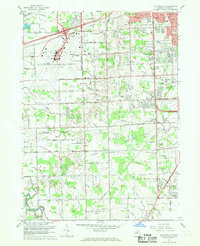 1967 Flat Rock NE1969 Print · USGSWayne County was undergoing a mid-century suburban shift when this survey recorded its complex drainage networks and expanding transport hubs. Genealogists can trace family landmarks like Krause Cem, John F Kennedy Sch, and Fellowship Ch.3 unique versions available
 - 1967 Map of Carleton, 1969 Print
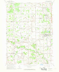 1967 Carleton1969 Print · USGSSoutheast Michigan's rural landscape is captured here in the late 1960s as a network of rail lines and drainage canals connected small farming communities. Genealogists can trace family landmarks like Woodmere Cem, St Patricks Sch, and the village of Waltz.3 unique versions available
 - 1967 Map of Flat Rock, 1969 Print
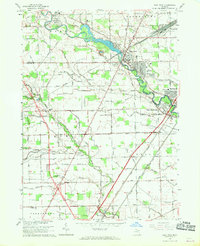 1967 Flat Rock1969 Print · USGSThe Huron River valley in the late sixties shows a landscape of industrial rail yards and growing residential communities. Genealogists can trace family landmarks like Ash-Center Cem, St Rochs Ch, and the many schools serving Flat Rock and Newport.2 unique versions available
 - 1967 Map of Belleville, 1969 Print
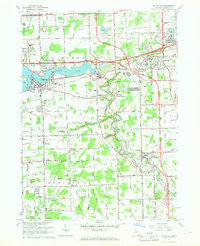 1967 Belleville1969 Print · USGSWayne County's suburban and rural landscape comes into focus in the late sixties as the freeway system expands through the Huron River valley. Researchers can trace family sites at Martinsville Cem, find early schools like Elwell Sch, and locate industrial hubs at French Landing.5 unique versions available
End of results
Showing maps 1-6 of 6
Top cities near Huron Charter Township
- Detroit historical maps
- Canton Township historical maps
- Canton Charter Township historical maps
- Livonia historical maps
- Dearborn historical maps
- Westland historical maps
See more
Top neighborhoods of Huron Charter Township
Frequently asked questions
- What are the different types of historical maps available for Huron Charter Township?
- What is the oldest map of Huron Charter Township?
- Where can I purchase historical maps of Huron Charter Township for my home or office?
- Where can I download high-res historical maps of Huron Charter Township?
- Are there historical topographic maps available for Huron Charter Township?
- Is there historical aerial imagery available for Huron Charter Township?
- Where are historical maps of Huron Charter Township sourced from?