1900s (20th Century) Maps of Clark Township, Minnesota
Explore 7 historic maps of Clark Township from the 1900s (20th Century). These maps offer a rare glimpse into what life looked like during the 1900s — showing old roads, neighborhoods, homes, and landmarks that have changed or disappeared over time.
Whether you're researching your family's past, planning a metal detecting trip, or studying how Clark Township's landscape evolved across the 1900s, these high-resolution maps are a powerful tool for exploring the history of this region.
- Focus on a specific era: All maps on this page are from the 1900s, giving you a focused view of this time period.
- See what’s changed: Compare century-old streets, trails, and buildings to today's modern landscape using overlays and satellite layers.
- Research with precision: Use these maps for genealogy, historical research, land use analysis, or educational projects.
- View, download, or print: Maps are fully viewable online in high resolution, and can be downloaded or printed for your own records.
Start exploring Clark Township's history through authentic maps from the 1900s. This is your window into the past.
Clark Township, MN maps
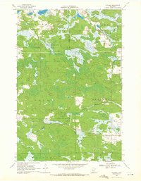
(7)- 1953 Map of Duluth, 1964 Print
 1953 Duluth1964 Print · USGSNortheastern Minnesota and northwestern Wisconsin are shown here during a period of industrial maturity and expanding conservation. Genealogists and historians can trace rail-connected towns like McGrath and Wahkon, or locate heritage sites within the Fond du Lac Indian Reservation.2 unique versions available
 - 1958 Map of Duluth
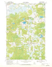
 1958 Duluth1958 Print · USGSNortheastern Minnesota and the Wisconsin borderlands are shown in detail during the late 1950s, centered on the bustling rail yards and ports of Duluth. You can trace the historic routes of the Soo Line and Duluth Missabe & Iron Range through small towns like McGrath, Bruno, and Wrenshall.
 - 1969 Map of Automba, 1972 Print
 1969 Automba1972 Print · USGSThe Aitkin County backcountry in the late sixties is a mosaic of dense woods and winding waterways. Trace the Soo Line rail corridor through the settlement of Automba or explore the wetlands of the Salo Marsh State Wildlife Management Area.
 - 1969 Map of Lawler, 1972 Print
 1969 Lawler1972 Print · USGSAitkin County in the late sixties reveals a landscape of northern timberlands and rail corridors. Researchers can locate community anchors like the Sheriff Lake Tabernacle and Salo Cem, or trace the winding Wakefield Brook near the village of Lawler.2 unique versions available
 - 1970 Map of Tamarack, 1972 Print
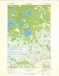 1970 Tamarack1972 Print · USGSThe Northwoods of Aitkin County are seen here in the early 1970s, defined by the Burlington Northern line and sprawling wetlands. Genealogists and local historians can locate Fairview Cem and the early footprints of Tamarack and Grayling.
 - 1970 Map of Wright, 1972 Print
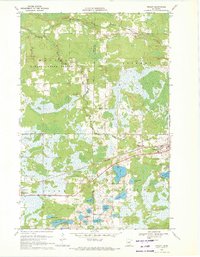 1970 Wright1972 Print · USGSCarlton County and Aitkin County meet in the early 1970s amid a dense network of timberlands and northern lakes. Researchers can trace family history through landmarks like Lakeside Cem and Wright, or follow the Burlington Northern corridor through the Savanna State Forest.2 unique versions available
 - 1994 Map of Aitkin
 1994 Aitkin1994 Print · USGSIn the mid-1990s, the lake country of central Minnesota remained a patchwork of state forests and rail-linked settlements. Researchers can trace the legacy of the Soo Line through towns like McGregor and Aitkin, or explore the vast reaches of the Savanna State Forest and Rice Lake.
End of results
Showing maps 1-7 of 7
Top cities near Clark Township
- McGregor historical maps
- Automba historical maps
- Wright historical maps
- Tamarack historical maps
- Libby historical maps
- Balsam historical maps
Frequently asked questions
- What are the different types of historical maps available for Clark Township?
- What is the oldest map of Clark Township?
- Where can I purchase historical maps of Clark Township for my home or office?
- Where can I download high-res historical maps of Clark Township?
- Are there historical topographic maps available for Clark Township?
- Is there historical aerial imagery available for Clark Township?
- Where are historical maps of Clark Township sourced from?