1950s Maps of Becker County, Minnesota
Explore 18 historic maps of Becker County from the 1950s. These maps offer a rare glimpse into what life looked like during the 1950s — showing old roads, neighborhoods, homes, and landmarks that have changed or disappeared over time.
Whether you're researching your family's past, planning a metal detecting trip, or studying how Becker County's landscape evolved across the 1950s, these high-resolution maps are a powerful tool for exploring the history of this region.
- Focus on a specific era: All maps on this page are from the 1950s, giving you a focused view of this time period.
- See what’s changed: Compare century-old streets, trails, and buildings to today's modern landscape using overlays and satellite layers.
- Research with precision: Use these maps for genealogy, historical research, land use analysis, or educational projects.
- View, download, or print: Maps are fully viewable online in high resolution, and can be downloaded or printed for your own records.
Start exploring Becker County's history through authentic maps from the 1950s. This is your window into the past.
Becker County, MN maps
(18)- 1952 Map of Grand Forks, 1967 Print
 1952 Grand Forks1967 Print · USGSThe Red River Valley in the early fifties is shown here at the height of its rail-and-river agricultural economy. Researchers can locate small-town landmarks like the Pleasant View School, the Immanuel Lutheran Church, and trace the path of the Soo Line Railroad.3 unique versions available
 - 1953 Map of Fargo, 1965 Print
 1953 Fargo1965 Print · USGSThe Red River Valley in the mid-fifties was a bustling rail and agricultural corridor during a period of steady prairie growth. Genealogists and historians can trace the intricate rail networks of the Great Northern and Soo Line connecting local hubs like Casselton and Wahpeton.2 unique versions available
 - 1953 Map of Brainerd, 1966 Print
 1953 Brainerd1966 Print · USGSCentral Minnesota's lake country and iron ranges are detailed in the mid-fifties, showing the intersection of industry and wilderness. Researchers can locate specific local landmarks like the Crow Wing County Courthouse or trace the early paths of the Soo Line Railroad and the Cuyuna Range Iron Mines.3 unique versions available
 - 1954 Map of Bemidji, 1966 Print
 1954 Bemidji1966 Print · USGSNorthern Minnesota's lake country and timberlands are captured here at a mid-century peak of rail and road expansion. Genealogists and historians can trace family roots through numerous small settlements like Mahnomen, Clearbrook, and Walker, while locating local landmarks such as White Earth Church.4 unique versions available
 - 1956 Map of Fargo
 1956 Fargo1956 Print · USGSThe Red River Valley's agricultural heartland is documented here in the mid-fifties as the rail-and-road network expanded across the plains. Genealogists can trace family roots through numerous small railroad towns and local landmarks like Casselton, Sheyenne Valley Church, and Sisseton Indian Res.
 - 1956 Map of Grand Forks
 1956 Grand Forks1956 Print · USGSThe Red River Valley in the mid-fifties is captured here as a thriving corridor of grain elevators and rail-linked towns along the North Dakota and Minnesota border. Researchers can trace historic church sites like Immanuel Lutheran Church, vanished rail stops at Tilde Junction, and the boundaries of the White Earth Indian Reservation.
 - 1957 Map of Brainerd
 1957 Brainerd1957 Print · USGSNorth-central Minnesota's lake-rich landscape is captured in the mid-1950s as a crossroads of rail, river, and forest. Genealogists and historians can trace the paths of the Great Northern and Soo Line railroads through hubs like Brainerd, Wadena, and Detroit Lakes.
 - 1957 Map of Bemidji
 1957 Bemidji1957 Print · USGSNorthern Minnesota in the mid-fifties is defined by its massive lake systems and the sprawling timberlands of the Chippewa National Forest. Genealogists and researchers can trace old rail lines like the Great Northern RR and locate settlements such as Moberg, Naytahwaush, and Lake Itasca.
 - 1958 Map of Bemidji
 1958 Bemidji1958 Print · USGSNorthern Minnesota in the late fifties is a vast landscape of tribal lands and timber forests tied together by rail. Genealogists and researchers can trace old rail stops and lakeside communities from Walker to Fosston, or explore the source of the Mississippi at Lake Itasca.
 - 1958 Map of Brainerd
 1958 Brainerd1958 Print · USGSCentral Minnesota in the late fifties is a landscape of dense lake chains, rail hubs, and sprawling state forests. Genealogists and local historians can trace old property alignments near the Mississippi River or locate family sites in Brainerd, Little Falls, and Detroit Lakes.
 - 1959 Map of Toad Mountain, 1960 Print
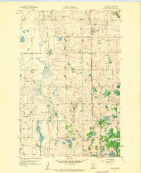
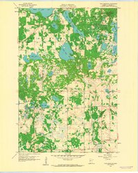 1959 Toad Mountain1960 Print · USGSBecker County’s lake country is captured here in the late fifties, showcasing a landscape of dense wetlands and rising terrain. Genealogists and local researchers can locate rural landmarks like Silver Birch Sch, St Johns Ch, and the Town Hall near Little Toad Lake.3 unique versions available
 - 1959 Map of Flat Lake, 1960 Print
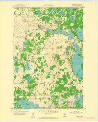
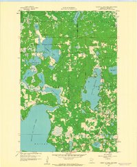
 1959 Flat Lake1960 Print · USGSBecker County in the late fifties shows a landscape of glacial lakes and protected wetlands. Researchers can trace the White Earth Indian Reservation Boundary alongside landmarks like Egelund Ch and School No 64.3 unique versions available
 - 1959 Map of Rochert, 1960 Print
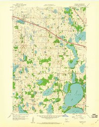
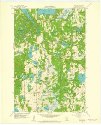 1959 Rochert1960 Print · USGSThe lakeside community of Rochert and the surrounding townships were defined by a complex network of glacial lakes and river systems in the late fifties. You can trace early local infrastructure through landmarks like Riverside School, Chilton Cemetery, and the Hubbel Pond Game Refuge.3 unique versions available
 - 1959 Map of Richwood, 1960 Print
 1959 Richwood1960 Print · USGSBecker County in the late fifties is a landscape of interconnected glacial lakes and rural townships. Trace the sites of local landmarks like Buffalo Lake Cem, Richwood, and various country schools including Bakke Sch and Pelican Valley Sch.2 unique versions available
 - 1959 Map of Callaway, 1960 Print
 1959 Callaway1960 Print · USGSBecker County was a patchwork of reservation lands and rail-stop villages in the late fifties. Researchers can trace the White Earth Indian Reservation Boundary and locate historic sites like St Marys Cem and Richwood Ch.
 - 1959 Map of Height Of Land Lake, 1960 Print
 1959 Height Of Land Lake1960 Print · USGSBecker County’s glacial lake country is captured here in the late fifties, where timberlands meet the reservation border. Genealogists and local historians can trace rural landmarks like School No 81, the Town Hall, and the winding path of the Otter Tail River.2 unique versions available
 - 1959 Map of Audubon, 1960 Print
 1959 Audubon1960 Print · USGSBecker County's lake country is captured here in the late fifties, showcasing a landscape of glacial basins and early mid-century growth. Genealogists and local historians can trace rural roots at Immanuel Cem, the Maple Grove Sch, and along the Northern Pacific rail line.3 unique versions available
 - 1959 Map of Detroit Lakes, 1960 Print
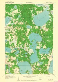
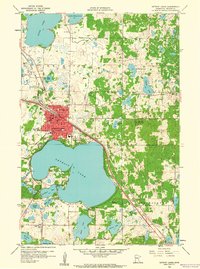 1959 Detroit Lakes1960 Print · USGSDetroit Lakes and its surrounding townships are shown here in the late fifties, during a period of steady mid-century growth. Genealogists can locate family landmarks such as Oak Grove Cem and several neighborhood schools including Rossman Sch and Lake View Sch.2 unique versions available
End of results
Showing maps 1-18 of 18
Top cities of Becker County
- Detroit Lakes historical maps
- Lake Eunice historical maps
- Frazee historical maps
- Cormorant historical maps
- White Earth historical maps
- Lake Park historical maps
See more
Frequently asked questions
- What are the different types of historical maps available for Becker County?
- What is the oldest map of Becker County?
- Where can I purchase historical maps of Becker County for my home or office?
- Where can I download high-res historical maps of Becker County?
- Are there historical topographic maps available for Becker County?
- Is there historical aerial imagery available for Becker County?
- Where are historical maps of Becker County sourced from?