1970s Maps of Becker County, Minnesota
Explore 8 historic maps of Becker County from the 1970s. These maps offer a rare glimpse into what life looked like during the 1970s — showing old roads, neighborhoods, homes, and landmarks that have changed or disappeared over time.
Whether you're researching your family's past, planning a metal detecting trip, or studying how Becker County's landscape evolved across the 1970s, these high-resolution maps are a powerful tool for exploring the history of this region.
- Focus on a specific era: All maps on this page are from the 1970s, giving you a focused view of this time period.
- See what’s changed: Compare century-old streets, trails, and buildings to today's modern landscape using overlays and satellite layers.
- Research with precision: Use these maps for genealogy, historical research, land use analysis, or educational projects.
- View, download, or print: Maps are fully viewable online in high resolution, and can be downloaded or printed for your own records.
Start exploring Becker County's history through authentic maps from the 1970s. This is your window into the past.
Becker County, MN maps
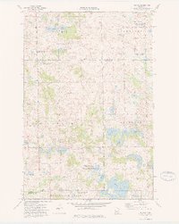
(8)- 1972 Map of Two Inlets, 1974 Print
 1972 Two Inlets1974 Print · USGSBecker County's lake-strewn timberland is captured here in the early seventies, combining aerial imagery with topographic detail. Genealogists and historians can locate Goldenrod, Evergreen Cemetery, and the shores of Two Inlets Lake or Little Mantrap Lake.
 - 1972 Map of Lake Itasca, 1974 Print
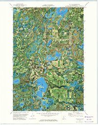
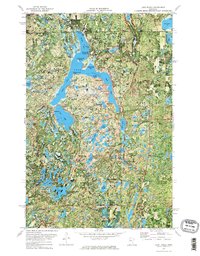 1972 Lake Itasca1974 Print · USGSIn the early 1970s, the headwaters of the Mississippi River remained a focal point of conservation and research within the dense woods of Northern Minnesota. Researchers and genealogists can trace the layout of the Univ of Minn Forestry Sch, locate the Pioneer Cem, and find old landmarks like the Alton Heights Lookout Tower.2 unique versions available
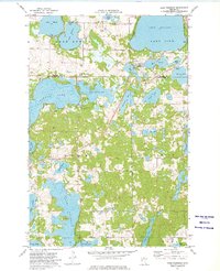
 - 1973 Map of Cormorant, 1975 Print
 1973 Cormorant1975 Print · USGSWestern Minnesota’s lake country is captured in the early seventies as the seasonal and permanent communities of Becker and Otter Tail Counties continued to develop. Researchers can trace local history at Cormorant Cem, Dunvilla, and the winding Pelican River.
 - 1973 Map of Little Pine Lake, 1975 Print
 1973 Little Pine Lake1975 Print · USGSOtter Tail County's lake country is captured in the early 1970s, showing the intricate waterways between Little Pine Lake and Big Pine Lake. Genealogists and historians can locate old burial grounds like Bauck Cem and trace the original BN rail corridor near Perham.
 - 1973 Map of Rollag, 1975 Print
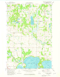
 1973 Rollag1975 Print · USGSThe borderlands of Clay and Otter Tail counties are captured here in the early seventies, showing a landscape of prairie potholes and small rural crossroads. Researchers can locate family landmarks like Grong Ch, Aspelund Cem, and the Woodland Sch No 3 near Rollag.
 - 1973 Map of Lake Franklin, 1975 Print
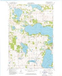
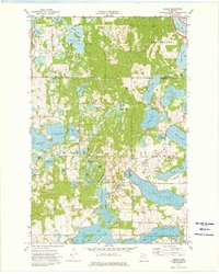
 1973 Lake Franklin1975 Print · USGSIn the lake-country of the early seventies, this survey traces the township lines of Dunn and Candor through a terrain of complex waterways. Genealogists and local historians can find family landmarks like Bucks Mill, Lake Eunice Cemetery, and Augustana Church.
 - 1973 Map of Vergas, 1975 Print
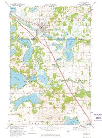
 1973 Vergas1975 Print · USGSThe lake country of Otter Tail County is meticulously detailed in the early seventies, centered on the village of Vergas. Genealogists and local researchers can trace historic property boundaries and find several local burial grounds like St Johns Cem and Free Thought Cem.
 - 1973 Map of Frazee, 1976 Print
 1973 Frazee1976 Print · USGSFrazee and its surrounding lake country are captured in the 1970s as the railroad and river define the region's geography. Genealogists and local historians can trace family locations near Sacred Heart Cem or the smaller settlement of Luce.
End of results
Showing maps 1-8 of 8
Top cities of Becker County
- Detroit Lakes historical maps
- Lake Eunice historical maps
- Frazee historical maps
- Cormorant historical maps
- White Earth historical maps
- Lake Park historical maps
See more
Frequently asked questions
- What are the different types of historical maps available for Becker County?
- What is the oldest map of Becker County?
- Where can I purchase historical maps of Becker County for my home or office?
- Where can I download high-res historical maps of Becker County?
- Are there historical topographic maps available for Becker County?
- Is there historical aerial imagery available for Becker County?
- Where are historical maps of Becker County sourced from?