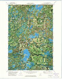
1972 Map of Two Inlets
USGS Topo · Published 1974About this map
Two Inlets State Forest dominates this orthophotomap, showing the dense glacial landscape on the border of Becker and Hubbard Counties. This 1972 survey combines aerial photography with topographic contour lines, revealing the intricate water systems that define the region. Large water bodies like Two Inlets Lake and Little Mantrap Lake are connected by Two Inlets Creek, while smaller, uniquely named features such as Hungry Man Lakes, Dinner Lake, and Hemphill Lake are scattered throughout the wooded terrain. Human activity is evidenced by the tiny settlement of Goldenrod, a local Townhall, and the Evergreen Cemetery. The map also traces a Pipeline cutting through the forest and notes recreation sites including a Campground and Public Access points for boaters. This specific edition provides an unfiltered look at the timber and lake country before significant modern development, preserving the footprint of the mid-century northern Minnesota wilderness.
Find a feature on this map
30 named features on this map. Tap any name to fly to it.
Don’t see what you’re looking for? This feature index may not catch every label — zoom into the map to look around manually.
Map Details
Editions of this 1972 Two Inlets Map
This is the sole edition of this map. No revisions or reprints were ever made.
Other maps of this area

1953 · Brainerd
USGS Topo · 1:250,000

1954 · Bemidji
USGS Topo · 1:250,000

1957 · Brainerd
USGS Topo · 1:250,000

1957 · Bemidji
USGS Topo · 1:250,000

1958 · Bemidji
USGS Topo · 1:250,000

1958 · Brainerd
USGS Topo · 1:250,000

1965 · Brainerd
USGS Topo · 1:250,000

1969 · Park Rapids
USGS Topo · 1:24,000

1969 · Anchor Hill
USGS Topo · 1:24,000

1969 · Big Basswood Lake
USGS Topo · 1:24,000