1970s Maps of Beseman Township, Minnesota
Explore 2 historic maps of Beseman Township from the 1970s. These maps offer a rare glimpse into what life looked like during the 1970s — showing old roads, neighborhoods, homes, and landmarks that have changed or disappeared over time.
Whether you're researching your family's past, planning a metal detecting trip, or studying how Beseman Township's landscape evolved across the 1970s, these high-resolution maps are a powerful tool for exploring the history of this region.
- Focus on a specific era: All maps on this page are from the 1970s, giving you a focused view of this time period.
- See what’s changed: Compare century-old streets, trails, and buildings to today's modern landscape using overlays and satellite layers.
- Research with precision: Use these maps for genealogy, historical research, land use analysis, or educational projects.
- View, download, or print: Maps are fully viewable online in high resolution, and can be downloaded or printed for your own records.
Start exploring Beseman Township's history through authentic maps from the 1970s. This is your window into the past.
Beseman Township, MN maps
(2)- 1970 Map of Little Prairie Lake, 1972 Print
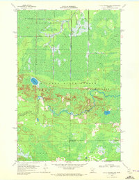 1970 Little Prairie Lake1972 Print · USGSThe northern Minnesota wilderness at the junction of three counties is captured here in the early seventies. Outdoorsmen and historians can trace the paths of the Snowmobile Trail and Winter Trail near Little Prairie Lake and the Savanna River.
 - 1970 Map of Wright, 1972 Print
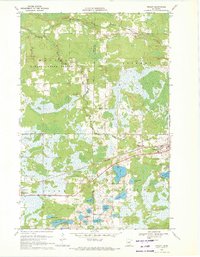 1970 Wright1972 Print · USGSCarlton County and Aitkin County meet in the early 1970s amid a dense network of timberlands and northern lakes. Researchers can trace family history through landmarks like Lakeside Cem and Wright, or follow the Burlington Northern corridor through the Savanna State Forest.2 unique versions available
End of results
Showing maps 1-2 of 2
Top cities near Beseman Township
- Floodwood historical maps
- Cromwell historical maps
- Automba historical maps
- Wright historical maps
- Tamarack historical maps
- Balsam historical maps
Frequently asked questions
- What are the different types of historical maps available for Beseman Township?
- What is the oldest map of Beseman Township?
- Where can I purchase historical maps of Beseman Township for my home or office?
- Where can I download high-res historical maps of Beseman Township?
- Are there historical topographic maps available for Beseman Township?
- Is there historical aerial imagery available for Beseman Township?
- Where are historical maps of Beseman Township sourced from?