1960s Maps of North Carlton, Minnesota
Explore 3 historic maps of North Carlton from the 1960s. These maps offer a rare glimpse into what life looked like during the 1960s — showing old roads, neighborhoods, homes, and landmarks that have changed or disappeared over time.
Whether you're researching your family's past, planning a metal detecting trip, or studying how North Carlton's landscape evolved across the 1960s, these high-resolution maps are a powerful tool for exploring the history of this region.
- Focus on a specific era: All maps on this page are from the 1960s, giving you a focused view of this time period.
- See what’s changed: Compare century-old streets, trails, and buildings to today's modern landscape using overlays and satellite layers.
- Research with precision: Use these maps for genealogy, historical research, land use analysis, or educational projects.
- View, download, or print: Maps are fully viewable online in high resolution, and can be downloaded or printed for your own records.
Start exploring North Carlton's history through authentic maps from the 1960s. This is your window into the past.
North Carlton, MN maps
(3)- 1961 Map of Cromwell, 1963 Print
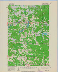 1961 Cromwell1963 Print · USGSCarlton County in the early sixties remains a region of quiet rail towns and deep glacial lakes. Genealogists and historians can trace family roots through landmarks like Finnish Ch, Kalevala Sch, and the West Branch Cem.2 unique versions available
 - 1963 Map of Gowan, 1964 Print
 1963 Gowan1964 Print · USGSNorthern Minnesota timberland and river valleys are captured here in the early sixties, showing the vital link between water and rail. Researchers can locate the small stations of Gowan and Paupores along the Great Northern railroad line.3 unique versions available
 - 1963 Map of Prairie Lake, 1964 Print
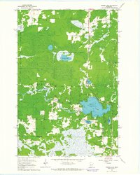 1963 Prairie Lake1964 Print · USGSNorthern Minnesota lake country is captured here in the early sixties, showing the rural townships of Halden and Floodwood. Genealogists and local historians can trace family-named sites like Moberg Lake, find the old Townhall, and locate both the Prairie Lake Cem and Fine Lake Cem.
End of results
Showing maps 1-3 of 3
Top cities near North Carlton
- Cloquet historical maps
- Moose Lake historical maps
- Barnum historical maps
- Mahtowa historical maps
- Floodwood historical maps
- Atkinson historical maps
See more
Top neighborhoods of North Carlton
Frequently asked questions
- What are the different types of historical maps available for North Carlton?
- What is the oldest map of North Carlton?
- Where can I purchase historical maps of North Carlton for my home or office?
- Where can I download high-res historical maps of North Carlton?
- Are there historical topographic maps available for North Carlton?
- Is there historical aerial imagery available for North Carlton?
- Where are historical maps of North Carlton sourced from?