1960s Maps of Waterford Township, Minnesota
Explore 2 historic maps of Waterford Township from the 1960s. These maps offer a rare glimpse into what life looked like during the 1960s — showing old roads, neighborhoods, homes, and landmarks that have changed or disappeared over time.
Whether you're researching your family's past, planning a metal detecting trip, or studying how Waterford Township's landscape evolved across the 1960s, these high-resolution maps are a powerful tool for exploring the history of this region.
- Focus on a specific era: All maps on this page are from the 1960s, giving you a focused view of this time period.
- See what’s changed: Compare century-old streets, trails, and buildings to today's modern landscape using overlays and satellite layers.
- Research with precision: Use these maps for genealogy, historical research, land use analysis, or educational projects.
- View, download, or print: Maps are fully viewable online in high resolution, and can be downloaded or printed for your own records.
Start exploring Waterford Township's history through authentic maps from the 1960s. This is your window into the past.
Waterford Township, MN maps
(2)- 1960 Map of Northfield, 1961 Print
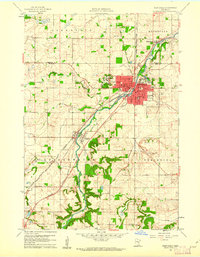 1960 Northfield1961 Print · USGSNorthfield and its surrounding townships are shown at a peak of mid-century growth, serving as a vital rail junction between the Twin Cities and southern Minnesota. Researchers can trace institutional grounds at St Olaf College and Carleton College or find rural landmarks like Little Prairie Ch and Dundas.2 unique versions available
 - 1960 Map of Dennison, 1961 Print
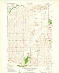 1960 Dennison1961 Print · USGSSoutheast Minnesota's agricultural heartland is documented here at the start of the 1960s. Family historians and researchers can trace the rail-side growth of Dennison and Stanton, locate the Prairie Creek Cem, and find landmarks like Carleton Airport.
End of results
Showing maps 1-2 of 2
Top cities near Waterford Township
- Burnsville historical maps
- Lakeville historical maps
- Apple Valley historical maps
- Savage historical maps
- Faribault historical maps
- Rosemount historical maps
See more
Top neighborhoods of Waterford Township
Frequently asked questions
- What are the different types of historical maps available for Waterford Township?
- What is the oldest map of Waterford Township?
- Where can I purchase historical maps of Waterford Township for my home or office?
- Where can I download high-res historical maps of Waterford Township?
- Are there historical topographic maps available for Waterford Township?
- Is there historical aerial imagery available for Waterford Township?
- Where are historical maps of Waterford Township sourced from?