
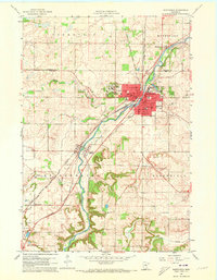
1960 Map of Northfield
USGS Topo · Published 1961About this map
Northfield serves as a prominent educational and industrial hub at the convergence of several major rail lines in the early 1960s. The academic campuses of St Olaf College and Carleton College anchor the city, while the Cannon River winds through the center, flanked by the Chicago Rock Island and Pacific and Minneapolis Northfield and Southern railroads. This network of tracks and waterways defines the town's layout, connecting it to smaller outlying settlements like Waterford to the north and Dundas to the south.
Find a feature on this map
35 named features on this map. Tap any name to fly to it.
Don’t see what you’re looking for? This feature index may not catch every label — zoom into the map to look around manually.
Map Details
Editions of this 1960 Northfield Map
2 editions found
Other maps of this area

1953 · Saint Paul
USGS Topo · 1:250,000

1957 · Farmington
USGS Topo · 1:62,500

1957 · Prior Lake
USGS Topo · 1:62,500

1959 · Saint Paul
USGS Topo · 1:250,000

1960 · Faribault
USGS Topo · 1:24,000

1960 · Cannon City
USGS Topo · 1:24,000

1960 · Dennison
USGS Topo · 1:24,000

1960 · Little Chicago
USGS Topo · 1:24,000

1960 · Nerstrand
USGS Topo · 1:24,000
1974 · New Market
USGS Topo · 1:24,000