1970s Maps of Barrett, Minnesota
Explore 2 historic maps of Barrett from the 1970s. These maps offer a rare glimpse into what life looked like during the 1970s — showing old roads, neighborhoods, homes, and landmarks that have changed or disappeared over time.
Whether you're researching your family's past, planning a metal detecting trip, or studying how Barrett's landscape evolved across the 1970s, these high-resolution maps are a powerful tool for exploring the history of this region.
- Focus on a specific era: All maps on this page are from the 1970s, giving you a focused view of this time period.
- See what’s changed: Compare century-old streets, trails, and buildings to today's modern landscape using overlays and satellite layers.
- Research with precision: Use these maps for genealogy, historical research, land use analysis, or educational projects.
- View, download, or print: Maps are fully viewable online in high resolution, and can be downloaded or printed for your own records.
Start exploring Barrett's history through authentic maps from the 1970s. This is your window into the past.
Barrett, MN maps
(2)- 1973 Map of Elbow Lake, 1975 Print
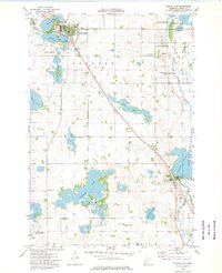 1973 Elbow Lake1975 Print · USGSGrant County’s lake-strewn landscape is captured in the early 1970s, showing the agricultural hubs of Elbow Lake and Barrett. Researchers can trace the path of the SOO LINE and locate several rural landmarks like Immanuel Ch and Bethania Cem.
 - 1973 Map of Erdahl, 1975 Print
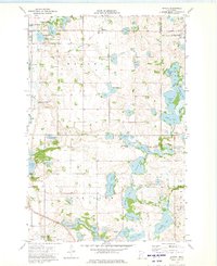 1973 Erdahl1975 Print · USGSGrant County is captured in the early 1970s, showing a transition between the Soo Line rail corridor and the surrounding glacial lake district. Genealogists and local historians can trace family ties at the Lincoln Cem, Zionaborg Cem, and the Townhall near Erdahl.
End of results
Showing maps 1-2 of 2
Top cities near Barrett
- Elbow Lake historical maps
- Hoffman historical maps
- Evansville historical maps
- Ashby historical maps
- Erdahl historical maps
- Kensington historical maps
See more
Frequently asked questions
- What are the different types of historical maps available for Barrett?
- What is the oldest map of Barrett?
- Where can I purchase historical maps of Barrett for my home or office?
- Where can I download high-res historical maps of Barrett?
- Are there historical topographic maps available for Barrett?
- Is there historical aerial imagery available for Barrett?
- Where are historical maps of Barrett sourced from?