1900s (20th Century) Maps of Norcross, Minnesota
Explore 6 historic maps of Norcross from the 1900s (20th Century). These maps offer a rare glimpse into what life looked like during the 1900s — showing old roads, neighborhoods, homes, and landmarks that have changed or disappeared over time.
Whether you're researching your family's past, planning a metal detecting trip, or studying how Norcross's landscape evolved across the 1900s, these high-resolution maps are a powerful tool for exploring the history of this region.
- Focus on a specific era: All maps on this page are from the 1900s, giving you a focused view of this time period.
- See what’s changed: Compare century-old streets, trails, and buildings to today's modern landscape using overlays and satellite layers.
- Research with precision: Use these maps for genealogy, historical research, land use analysis, or educational projects.
- View, download, or print: Maps are fully viewable online in high resolution, and can be downloaded or printed for your own records.
Start exploring Norcross's history through authentic maps from the 1900s. This is your window into the past.
Norcross, MN maps
(6)- 1911 Map of Herman
 1911 Herman1911 Print · USGSThe junction of two major rail lines at Herman defines this prairie landscape during a period of steady agricultural growth. Researchers can locate nearly twenty numbered rural schoolhouses and trace the original paths of the Great Northern RR and the Mustinka River.3 unique versions available
 - 1953 Map of Milbank, 1958 Print
 1953 Milbank1958 Print · USGSThe tri-state border region of South Dakota, North Dakota, and Minnesota is shown here during the early fifties, a landscape defined by glacial lakes and the Sisseton Indian Reservation. Researchers can trace the legacy of the western railroads, locating old stops along the Great Northern and settlements like Milbank, Webster, and Sisseton.3 unique versions available
 - 1958 Map of Milbank
 1958 Milbank1958 Print · USGSThe northern Great Plains in the late fifties show a landscape of glacial lakes and reservation lands shaped by the Great Northern railroad. Genealogists and local historians can trace the grid of settlements from Britton to Milbank and locate landmarks like Enemy Swim Lake and the Sisseton Indian Reservation.
 - 1973 Map of Herman NW, 1975 Print
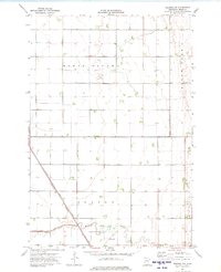 1973 Herman NW1975 Print · USGSIn the early 1970s, these Grant County townships were defined by the intersection of prairie agriculture and vital rail transport. Trace the diagonal path of the Burlington Northern railroad past Bullis or follow the Mustinka River through the heart of the prairie.
 - 1973 Map of Herman, 1975 Print
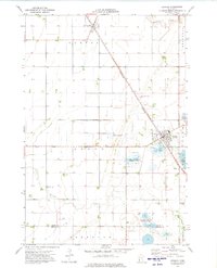 1973 Herman1975 Print · USGSWestern Minnesota’s agricultural prairie and rail-side settlements are captured here in the early 1970s. Trace local history through landmarks like Herman, Norcross, and the Eden Reformed Cem along the diagonal Burlington Northern line.
 - 1985 Map of Wheaton
 1985 Wheaton1985 Print · USGSThe tri-state border region of Minnesota and the Dakotas is captured in the mid-1980s, defined by its prairie wetlands and rail-fed farming towns. Researchers can trace the Burlington Northern line through Wheaton and Graceville or locate family-named landmarks like Carlson Island.2 unique versions available
End of results
Showing maps 1-6 of 6
Top cities near Norcross
- Elbow Lake historical maps
- Herman historical maps
- Donnelly historical maps
- Wendell historical maps
- Dumont historical maps
- Tintah historical maps
See more
Frequently asked questions
- What are the different types of historical maps available for Norcross?
- What is the oldest map of Norcross?
- Where can I purchase historical maps of Norcross for my home or office?
- Where can I download high-res historical maps of Norcross?
- Are there historical topographic maps available for Norcross?
- Is there historical aerial imagery available for Norcross?
- Where are historical maps of Norcross sourced from?