1980s Maps of Kandiyohi, Minnesota
Explore 2 historic maps of Kandiyohi from the 1980s. These maps offer a rare glimpse into what life looked like during the 1980s — showing old roads, neighborhoods, homes, and landmarks that have changed or disappeared over time.
Whether you're researching your family's past, planning a metal detecting trip, or studying how Kandiyohi's landscape evolved across the 1980s, these high-resolution maps are a powerful tool for exploring the history of this region.
- Focus on a specific era: All maps on this page are from the 1980s, giving you a focused view of this time period.
- See what’s changed: Compare century-old streets, trails, and buildings to today's modern landscape using overlays and satellite layers.
- Research with precision: Use these maps for genealogy, historical research, land use analysis, or educational projects.
- View, download, or print: Maps are fully viewable online in high resolution, and can be downloaded or printed for your own records.
Start exploring Kandiyohi's history through authentic maps from the 1980s. This is your window into the past.
Kandiyohi, MN maps
(2)- 1982 Map of Spicer, 1983 Print
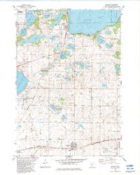 1982 Spicer1983 Print · USGSKandiyohi County was a landscape of conservation and lakeside living in the early eighties, centered on the growing town of Spicer. Researchers can trace old family sites near St Patrick Cem, early recreation at Green Lake Camp, and the rail corridor of the Burlington Northern.
 - 1986 Map of Litchfield
 1986 Litchfield1986 Print · USGSCentral Minnesota in the mid-eighties was a landscape of conservation and transport, where the Burlington Northern rail line connected thriving lake towns. Genealogists and historians can trace old townships and landmarks like St Nicholas, Forest City, and School House Lake.2 unique versions available
End of results
Showing maps 1-2 of 2
Top cities near Kandiyohi
- Willmar historical maps
- New London historical maps
- Spicer historical maps
- Atwater historical maps
- Cosmos historical maps
- Roseland historical maps
See more
Frequently asked questions
- What are the different types of historical maps available for Kandiyohi?
- What is the oldest map of Kandiyohi?
- Where can I purchase historical maps of Kandiyohi for my home or office?
- Where can I download high-res historical maps of Kandiyohi?
- Are there historical topographic maps available for Kandiyohi?
- Is there historical aerial imagery available for Kandiyohi?
- Where are historical maps of Kandiyohi sourced from?