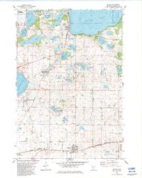
1982 Map of Spicer
USGS Topo · Published 1983About this map
The town of Spicer sits at the southern tip of the massive Green Lake, serving as a central hub for this lake-studded region of central Minnesota. In the late 1970s and early 1980s, the landscape was a mosaic of agricultural fields and extensive conservation areas, including the Ringo-Nest State Wildlife Management Area and several scattered tracts of the National Waterfowl Production Area. The Burlington Northern railroad cuts a straight line through the topography, connecting the waterfront at Spicer to the community of Kandiyohi to the south. Local heritage is preserved at sites like St Patrick Cem and Green Lake Ch, while recreational activity is anchored by the Green Lake Camp and Decision Hills Camp. The presence of numerous smaller bodies like Elkhorn Lake and Burr Oak Lake highlights the post-glacial geography that has long defined the region’s economy and natural character.
Find a feature on this map
40 named features on this map. Tap any name to fly to it.
Don’t see what you’re looking for? This feature index may not catch every label — zoom into the map to look around manually.
Map Details
Editions of this 1982 Spicer Map
This is the sole edition of this map. No revisions or reprints were ever made.
Other maps of this area

1953 · Saint Cloud
USGS Topo · 1:250,000

1956 · Atwater
USGS Topo · 1:62,500

1957 · Saint Cloud
USGS Topo · 1:250,000

1958 · Saint Cloud
USGS Topo · 1:250,000

1958 · Willmar
USGS Topo · 1:24,000

1958 · Solomon Lake
USGS Topo · 1:24,000

1967 · Mount Tom
USGS Topo · 1:24,000

1967 · Hawick
USGS Topo · 1:24,000
1967 · New London
USGS Topo · 1:24,000
1982 · Lake Elizabeth
USGS Topo · 1:24,000