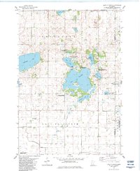
1982 Map of Lake Elizabeth
USGS Topo · Published 1983About this map
Lake Elizabeth and its prominent Big Island define this glaciated landscape in Kandiyohi County. The early 1980s terrain is characterized by a high density of wetlands and protected areas, including the Gennesse State Wildlife Management Area and multiple waterfowl production sites. Rural life is anchored by a network of local landmarks such as the Townhall and several historical burial grounds, including Union Cem and the Lake Elizabeth Cem. The presence of Gravel Pits and various drainage features like Ditch point to the area's agricultural and industrial utility. Smaller water bodies like Summit Lake and Mennetaga Lake dot the township, while the border between Gennesse and Acton reflects the grid-based settlement pattern typical of the Minnesota prairie.
Find a feature on this map
35 named features on this map. Tap any name to fly to it.
Don’t see what you’re looking for? This feature index may not catch every label — zoom into the map to look around manually.
Map Details
Editions of this 1982 Lake Elizabeth Map
This is the sole edition of this map. No revisions or reprints were ever made.
Other maps of this area

1953 · New Ulm
USGS Topo · 1:250,000

1953 · Saint Cloud
USGS Topo · 1:250,000

1956 · Atwater
USGS Topo · 1:62,500

1957 · Saint Cloud
USGS Topo · 1:250,000

1957 · New Ulm
USGS Topo · 1:250,000

1957 · Olivia
USGS Topo · 1:62,500

1958 · New Ulm
USGS Topo · 1:250,000

1958 · Saint Cloud
USGS Topo · 1:250,000

1967 · New Ulm
USGS Topo · 1:250,000

1967 · Grove City
USGS Topo · 1:24,000