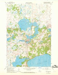
1967 Map of New London
USGS Topo · Published 1969About this map
The Middle Fork Crow River flows through a glaciated landscape of interconnected basins, shaping the development of New London in the late 1960s. This central Minnesota village serves as a hub between the expansive Mud Lake to the north and the deep waters of Nest Lake and Green Lake to the south. The land use reveals a mix of conservation and infrastructure, featuring the National Fish Hatchery near the town center and several protected zones like the Burbank State Wildlife Management Area. Transport and industry are marked by the Great Northern railroad line and various Gravel Pits that punctuate the shoreline areas. Local community life is anchored by landmarks such as Grace Ch and the town High Sch, while recreational footprints are visible at the Roadside Park and lakeshore Campground.
Find a feature on this map
28 named features on this map. Tap any name to fly to it.
Don’t see what you’re looking for? This feature index may not catch every label — zoom into the map to look around manually.
Map Details
Editions of this 1967 New London Map
This is the sole edition of this map. No revisions or reprints were ever made.
Other maps of this area

1953 · Saint Cloud
USGS Topo · 1:250,000

1956 · Atwater
USGS Topo · 1:62,500

1957 · Saint Cloud
USGS Topo · 1:250,000

1958 · Saint Cloud
USGS Topo · 1:250,000

1958 · Solomon Lake
USGS Topo · 1:24,000

1967 · Mount Tom
USGS Topo · 1:24,000

1967 · Belgrade
USGS Topo · 1:24,000
1967 · Georgeville
USGS Topo · 1:24,000

1967 · Hawick
USGS Topo · 1:24,000
1967 · Lake Henry
USGS Topo · 1:24,000