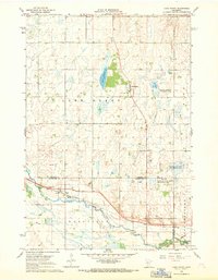
1967 Map of Lake Henry
USGS Topo · Published 1969About this map
Lake Henry and its surrounding prairie landscapes are preserved here in a detailed mid-century survey along the border of Stearns and Kandiyohi Counties. The area’s agrarian character is defined by the North Fork Crow River, which winds through the southern townships of Roseville and Zion. The tiny settlement of Regal sits at a junction along the Soo Line railroad, serving as a focal point for local transport near the St Anthony Cem. This region is also a vital habitat for migratory birds, evidenced by several designated conservation zones including the National Wildlife Management Area and the Zion State Wildlife Management Area. Cultural landmarks such as St Margaret Ch and the Grove Sch provide essential geographic markers for genealogists researching the rural communities that thrived here during the late 1960s.
Find a feature on this map
22 named features on this map. Tap any name to fly to it.
Don’t see what you’re looking for? This feature index may not catch every label — zoom into the map to look around manually.
Map Details
Editions of this 1967 Lake Henry Map
This is the sole edition of this map. No revisions or reprints were ever made.
Other maps of this area

1953 · Saint Cloud
USGS Topo · 1:250,000

1957 · Saint Cloud
USGS Topo · 1:250,000

1958 · Saint Cloud
USGS Topo · 1:250,000

1965 · Greenwald
USGS Topo · 1:24,000

1965 · Elrosa
USGS Topo · 1:24,000

1965 · St Martin
USGS Topo · 1:24,000

1967 · Paynesville
USGS Topo · 1:24,000

1967 · Lake Koronis
USGS Topo · 1:24,000
1967 · Georgeville
USGS Topo · 1:24,000

1967 · Hawick
USGS Topo · 1:24,000