1970s Maps of Lac qui Parle County, Minnesota
Explore 6 historic maps of Lac qui Parle County from the 1970s. These maps offer a rare glimpse into what life looked like during the 1970s — showing old roads, neighborhoods, homes, and landmarks that have changed or disappeared over time.
Whether you're researching your family's past, planning a metal detecting trip, or studying how Lac qui Parle County's landscape evolved across the 1970s, these high-resolution maps are a powerful tool for exploring the history of this region.
- Focus on a specific era: All maps on this page are from the 1970s, giving you a focused view of this time period.
- See what’s changed: Compare century-old streets, trails, and buildings to today's modern landscape using overlays and satellite layers.
- Research with precision: Use these maps for genealogy, historical research, land use analysis, or educational projects.
- View, download, or print: Maps are fully viewable online in high resolution, and can be downloaded or printed for your own records.
Start exploring Lac qui Parle County's history through authentic maps from the 1970s. This is your window into the past.
Lac qui Parle County, MN maps
(6)- 1971 Map of Odessa, 1974 Print
 1971 Odessa1974 Print · USGSBig Stone County and the Minnesota River valley are shown here in the early seventies, featuring the town of Odessa and its riverfront infrastructure. Researchers can trace the Milwaukee Road railroad and locate rural landmarks like Eidskog Ch and Immanuel Ch.
 - 1971 Map of Marietta, 1974 Print
 1971 Marietta1974 Print · USGSThe prairie borderlands of western Minnesota and eastern South Dakota come into focus during the early 1970s. Trace local history through the streets of Marietta and Nassau or locate rural sites like the Swedish Mission Ch and Pegg Lake.2 unique versions available
 - 1971 Map of Haydenville, 1974 Print
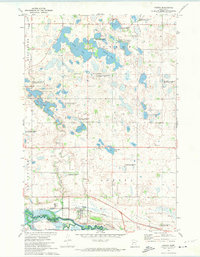
 1971 Haydenville1974 Print · USGSLac qui Parle County enters the 1970s as a landscape of structured agricultural townships and emerging wildlife conservation. Researchers can trace the diagonal Indian Treaty Boundary and locate family history at Lokken Cem or the settlement of Haydenville.
 - 1971 Map of Bellingham, 1974 Print
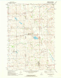
 1971 Bellingham1974 Print · USGSBellingham and the Lac qui Parle river country are captured in the early seventies during a period of highway expansion. Researchers can trace family sites via St Pauls Cem and Salem Cem or locate the historic Old Indian Treaty Bdy.
 - 1971 Map of Rosen, 1974 Print
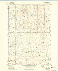
 1971 Rosen1974 Print · USGSThe Minnesota-South Dakota borderlands come into focus in the early 1970s as the river valleys intersect with historic land boundaries. Genealogists and historians can locate the St Johns Cem, the community of Rosen, and the path of the Old Indian Treaty Boundary.
 - 1971 Map of Ortonville, 1974 Print
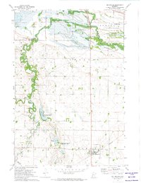
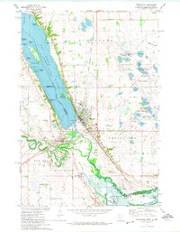 1971 Ortonville1974 Print · USGSBig Stone Lake and the upper Minnesota River define the state border in the early seventies, a landscape of water-based recreation and rail-side industry. Genealogists can trace family locations at Big Stone City, St Charles Cem, or the residential streets of Ortonville.
End of results
Showing maps 1-6 of 6
Top cities of Lac qui Parle County
- Madison historical maps
- Dawson historical maps
- Cerro Gordo historical maps
- Boyd historical maps
- Bellingham historical maps
- Providence historical maps
See more
Frequently asked questions
- What are the different types of historical maps available for Lac qui Parle County?
- What is the oldest map of Lac qui Parle County?
- Where can I purchase historical maps of Lac qui Parle County for my home or office?
- Where can I download high-res historical maps of Lac qui Parle County?
- Are there historical topographic maps available for Lac qui Parle County?
- Is there historical aerial imagery available for Lac qui Parle County?
- Where are historical maps of Lac qui Parle County sourced from?