1960s Maps of Lac qui Parle County, Minnesota
Explore 14 historic maps of Lac qui Parle County from the 1960s. These maps offer a rare glimpse into what life looked like during the 1960s — showing old roads, neighborhoods, homes, and landmarks that have changed or disappeared over time.
Whether you're researching your family's past, planning a metal detecting trip, or studying how Lac qui Parle County's landscape evolved across the 1960s, these high-resolution maps are a powerful tool for exploring the history of this region.
- Focus on a specific era: All maps on this page are from the 1960s, giving you a focused view of this time period.
- See what’s changed: Compare century-old streets, trails, and buildings to today's modern landscape using overlays and satellite layers.
- Research with precision: Use these maps for genealogy, historical research, land use analysis, or educational projects.
- View, download, or print: Maps are fully viewable online in high resolution, and can be downloaded or printed for your own records.
Start exploring Lac qui Parle County's history through authentic maps from the 1960s. This is your window into the past.
Lac qui Parle County, MN maps
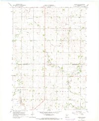
(14)- 1965 Map of Montevideo, 1966 Print
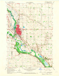 1965 Montevideo1966 Print · USGSThe river confluence at Montevideo flourished in the mid-sixties as a center for rail and river-valley transport. Researchers can trace family history through many local landmarks, including Sunset Memorial Cemetery, St Johns Ch, and the tiny settlement of Wegdahl.2 unique versions available
 - 1965 Map of Clarkfield, 1966 Print
 1965 Clarkfield1966 Print · USGSMid-century Yellow Medicine County is defined here by the diagonal tracks of the Chicago and North Western and a vast network of prairie wetlands. Trace the development of Clarkfield through its cemetery, Storage Bins, and the many wildlife areas like Lake Louie.
 - 1965 Map of Clarkfield NE, 1966 Print
 1965 Clarkfield NE1966 Print · USGSThe confluence of the Minnesota and Chippewa Rivers defines this rural landscape in the mid-1960s. Genealogists can trace family footprints at German American Cem and St Petri Cem, or locate landmarks like School No 839.
 - 1965 Map of Tenmile Lake, 1966 Print
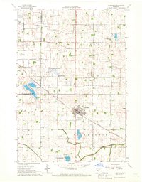
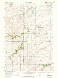
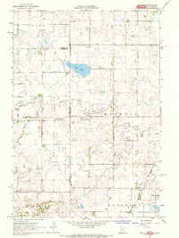
 1965 Tenmile Lake1966 Print · USGSLac Qui Parle County is captured in the mid-1960s as a productive agricultural landscape defined by its river bends and drainage networks. Genealogists and researchers can locate landmarks like Our Saviors Ch, the Townhall, and the Chicago and North Western rail line.
 - 1965 Map of Boyd, 1966 Print
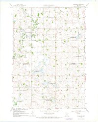
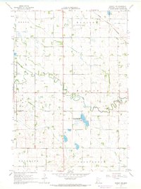
 1965 Boyd1966 Print · USGSThe rural prairie of Lac qui Parle and Yellow Medicine counties is captured in the mid-1960s as a landscape of structured drainage and rail-side commerce. Researchers can locate specific family history sites like Trinity Cem, the Zion Ch, and the township Townhall.
 - 1967 Map of New Ulm
 1967 New Ulm1967 Print · USGSSouthern Minnesota in the mid-fifties is captured here as a landscape of river-valley missions and busy prairie rail towns. Researchers can trace the Yellow Medicine Trail and locate historic sites like the Morton Indian Mission and Milford State Monument.
 - 1967 Map of Dawson SW, 1968 Print
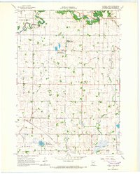
 1967 Dawson SW1968 Print · USGSLac qui Parle and Yellow Medicine counties meet here in the late sixties, showing a landscape defined by prairie agriculture and rural townships. Researchers can find deep local roots at the Providence Valley Ch or trace the winding Lazarus Creek.
 - 1967 Map of Gary, 1968 Print
 1967 Gary1968 Print · USGSCrossing the border between South Dakota and Minnesota in the late 1960s, this area centers on the town of Gary and its river-carved landscape. Genealogists and local researchers can trace early rural life through Grandview Cem, the Chicago and North Western rail line, and the Lac qui Parle State Game Refuge.2 unique versions available
 - 1967 Map of Providence, 1968 Print
 1967 Providence1968 Print · USGSThe rural borderlands of Lac qui Parle and Yellow Medicine counties are captured here in the late sixties, showing a landscape defined by prairie conservation and small-town life. Genealogists and local historians can trace the foundations of the area at Providence and find local landmarks like the Mission Covenant Ch or St Johns Sch.
 - 1967 Map of Gary SE, 1968 Print
 1967 Gary SE1968 Print · USGSThe rural prairie landscape of Lac qui Parle and Yellow Medicine Counties is captured here in the late sixties. Genealogists and local historians can locate community sites like Bethlehem Cem, the Florida Ch, and the C & NW railroad.
 - 1967 Map of Gary NW, 1968 Print
 1967 Gary NW1968 Print · USGSThe rural borderlands of Minnesota and South Dakota are captured in the late sixties, showing a landscape defined by prairie wetlands and small farming communities. Researchers can trace local lineage through the Antelope Valley Cem and Zoar Ch near Salt Lake.4 unique versions available
 - 1967 Map of Dawson, 1968 Print
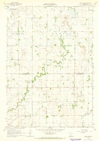
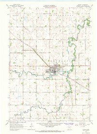 1967 Dawson1968 Print · USGSThe agricultural hub of Dawson flourished in the late sixties at the junction of the Lac Qui Parle River and the railroad. Genealogists and historians can trace the town's mid-century footprint, from the local Cemetery to the Drive-in Theater.
 - 1967 Map of Dawson NW, 1968 Print
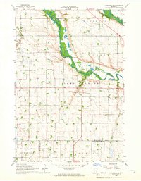
 1967 Dawson NW1968 Print · USGSLac qui Parle County in the late sixties is a landscape of prairie townships and river branches managed for agriculture. Genealogists and local historians can locate the Garfield Ch, Hamlin Cem, and multiple rural Townhall sites.2 unique versions available
 - 1967 Map of Mount Wickham, 1969 Print
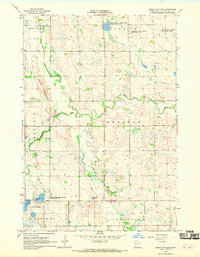 1967 Mount Wickham1969 Print · USGSWestern Minnesota prairie and river valleys are captured here in the late sixties, showing the structured township grids of the Lac qui Parle region. Researchers can trace the winding Lac qui Parle River, find the height of Mount Wickham, and locate local landmarks like the Bolland Sloughs.
End of results
Showing maps 1-14 of 14
Top cities of Lac qui Parle County
- Madison historical maps
- Dawson historical maps
- Cerro Gordo historical maps
- Boyd historical maps
- Bellingham historical maps
- Providence historical maps
See more
Frequently asked questions
- What are the different types of historical maps available for Lac qui Parle County?
- What is the oldest map of Lac qui Parle County?
- Where can I purchase historical maps of Lac qui Parle County for my home or office?
- Where can I download high-res historical maps of Lac qui Parle County?
- Are there historical topographic maps available for Lac qui Parle County?
- Is there historical aerial imagery available for Lac qui Parle County?
- Where are historical maps of Lac qui Parle County sourced from?