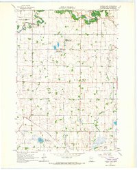
1965 Map of Tenmile Lake
USGS Topo · Published 1966About this map
The Lac Qui Parle River meanders through the northern reaches of this Minnesota landscape, its oxbows and wetlands define a region heavily shaped by both natural watercourses and 20th-century agricultural engineering. The intricate network of drainage features, including County Ditch No 34 and Judicial Ditch No 1, illustrates the systematic effort to manage the prairie floor for farming. This 1965 field-checked survey highlights a period of conservation, evidenced by the large footprints of the Baxter State Wildlife Management Area and the Ten-Well State Wildlife Management Area. Human activity is anchored by the Chicago and North Western railroad line cutting through the southwest and local landmarks like Our Saviors Ch and the Townhall, which served as the social centers for the surrounding townships of Baxter and Maxwell.
Find a feature on this map
22 named features on this map. Tap any name to fly to it.
Don’t see what you’re looking for? This feature index may not catch every label — zoom into the map to look around manually.
Map Details
Editions of this 1965 Tenmile Lake Map
This is the sole edition of this map. No revisions or reprints were ever made.
Other maps of this area

1953 · Milbank
USGS Topo · 1:250,000

1953 · Watertown
USGS Topo · 1:250,000

1953 · New Ulm
USGS Topo · 1:250,000

1953 · Saint Cloud
USGS Topo · 1:250,000

1957 · Saint Cloud
USGS Topo · 1:250,000

1957 · New Ulm
USGS Topo · 1:250,000

1958 · New Ulm
USGS Topo · 1:250,000

1958 · Milbank
USGS Topo · 1:250,000

1958 · Watertown
USGS Topo · 1:250,000

1958 · Saint Cloud
USGS Topo · 1:250,000