
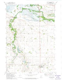
1971 Map of Odessa
USGS Topo · Published 1974About this map
Odessa stands as the primary settlement on the northern bank of the Minnesota River during this early 1970s survey. The landscape is defined by the complex glacial topography of the Agassiz region, characterized by numerous water bodies such as Otrey Lake, Larson Lake, and Long Tom Lake. This period captures a significant moment in local infrastructure development, clearly marking the Highway 75 Dam (Under Construction) just south of the town center.
Find a feature on this map
29 named features on this map. Tap any name to fly to it.
Don’t see what you’re looking for? This feature index may not catch every label — zoom into the map to look around manually.
Map Details
Editions of this 1971 Odessa Map
This is the sole edition of this map. No revisions or reprints were ever made.
Other maps of this area

1953 · Ortonville
USGS Topo · 1:62,500

1953 · Bellingham
USGS Topo · 1:62,500

1953 · Milbank
USGS Topo · 1:250,000

1958 · Milbank
USGS Topo · 1:250,000

1958 · Correll
USGS Topo · 1:24,000

1968 · Artichoke Lake NW
USGS Topo · 1:24,000

1968 · Artichoke Lake
USGS Topo · 1:24,000

1971 · Dismal Swamp
USGS Topo · 1:24,000
1971 · Bellingham
USGS Topo · 1:24,000

1971 · Rosen
USGS Topo · 1:24,000