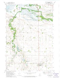
1971 Map of Bellingham
USGS Topo · Published 1974About this map
The Burlington Northern railroad corridor anchors the small community of Bellingham in this western Minnesota landscape during the early 1970s. The map illustrates a transition in local infrastructure, noting Highway 75 (Under Construction) cutting through the river valley. Water dominates the northern and western sections, where the Yellow Bank River meets the Minnesota River near the expansive Lac Qui Parle State Wildlife Management Area.
Find a feature on this map
29 named features on this map. Tap any name to fly to it.
Don’t see what you’re looking for? This feature index may not catch every label — zoom into the map to look around manually.
Map Details
Editions of this 1971 Bellingham Map
This is the sole edition of this map. No revisions or reprints were ever made.
Other maps of this area

1953 · Ortonville
USGS Topo · 1:62,500

1953 · Bellingham
USGS Topo · 1:62,500

1953 · Milbank
USGS Topo · 1:250,000

1958 · Milbank
USGS Topo · 1:250,000

1958 · Madison
USGS Topo · 1:24,000

1958 · Correll
USGS Topo · 1:24,000

1968 · Artichoke Lake
USGS Topo · 1:24,000

1971 · Odessa
USGS Topo · 1:24,000

1971 · Marietta
USGS Topo · 1:24,000
1971 · Haydenville
USGS Topo · 1:24,000