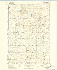
1971 Map of Haydenville
USGS Topo · Published 1974About this map
Haydenville stands as the primary settlement in this 1971 study of western Minnesota, situated amidst a landscape defined by organized townships and significant conservation efforts. The topography reveals the sprawling agricultural character of Perry, Arena, Walter, and Augusta, where the drainage of the Yellow Bank River winds through the prairie. A historical Indian Treaty Boundary cuts diagonally across the northern section, marking a legacy of land division that predates the modern section lines. Genealogists and local historians can locate specific sites such as Lokken Cem and Zion Cem, while the industrial history of the region is traced through the tracks of the Burlington Northern and an Old Railroad Grade. Extensive wetlands and habitat protections are evident in numerous preserves, including the Acton Marsh State Wildlife Management Area and the National Waterfowl Production Area.
Find a feature on this map
25 named features on this map. Tap any name to fly to it.
Don’t see what you’re looking for? This feature index may not catch every label — zoom into the map to look around manually.
Map Details
Editions of this 1971 Haydenville Map
This is the sole edition of this map. No revisions or reprints were ever made.
Other maps of this area

1953 · Bellingham
USGS Topo · 1:62,500

1953 · Milbank
USGS Topo · 1:250,000

1953 · Watertown
USGS Topo · 1:250,000

1958 · Milbank
USGS Topo · 1:250,000

1958 · Watertown
USGS Topo · 1:250,000

1958 · Madison
USGS Topo · 1:24,000

1958 · Correll
USGS Topo · 1:24,000

1967 · Gary NW
USGS Topo · 1:24,000
1967 · Dawson NW
USGS Topo · 1:24,000
1967 · Mount Wickham
USGS Topo · 1:24,000