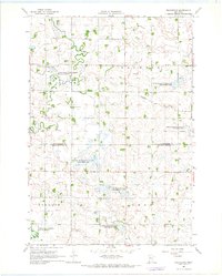
1967 Map of Providence
USGS Topo · Published 1968About this map
The Lac qui Parle River meanders through the northern reaches of this rural landscape, defining a terrain largely shaped by agricultural drainage and conservation efforts. During the late 1960s, the boundary between Lac qui Parle and Yellow Medicine counties was characterized by a transition from organized townships like Providence and Maxwell to an extensive network of protected lands. The map reveals a high concentration of conservation sites, including the Providence State Wildlife Management Area and the Big Rock State Wildlife Management Area, which preserve the natural prairie-marsh character amidst the surrounding grid of section lines. Small community centers are marked by landmarks such as the Mission Covenant Ch and the St Johns Sch, while the drainage of the land is meticulously documented through features like Tenmile Judicial Ditch No 8 Creek and Spring Creek.
Find a feature on this map
22 named features on this map. Tap any name to fly to it.
Don’t see what you’re looking for? This feature index may not catch every label — zoom into the map to look around manually.
Map Details
Editions of this 1967 Providence Map
This is the sole edition of this map. No revisions or reprints were ever made.
Other maps of this area

1953 · Watertown
USGS Topo · 1:250,000

1953 · New Ulm
USGS Topo · 1:250,000

1957 · New Ulm
USGS Topo · 1:250,000

1958 · New Ulm
USGS Topo · 1:250,000

1958 · Watertown
USGS Topo · 1:250,000
1965 · Tenmile Lake
USGS Topo · 1:24,000

1965 · Boyd
USGS Topo · 1:24,000

1967 · New Ulm
USGS Topo · 1:250,000

1967 · Dawson SW
USGS Topo · 1:24,000

1967 · Porter
USGS Topo · 1:24,000