1980s Maps of Stony River Township, Minnesota
Explore 20 historic maps of Stony River Township from the 1980s. These maps offer a rare glimpse into what life looked like during the 1980s — showing old roads, neighborhoods, homes, and landmarks that have changed or disappeared over time.
Whether you're researching your family's past, planning a metal detecting trip, or studying how Stony River Township's landscape evolved across the 1980s, these high-resolution maps are a powerful tool for exploring the history of this region.
- Focus on a specific era: All maps on this page are from the 1980s, giving you a focused view of this time period.
- See what’s changed: Compare century-old streets, trails, and buildings to today's modern landscape using overlays and satellite layers.
- Research with precision: Use these maps for genealogy, historical research, land use analysis, or educational projects.
- View, download, or print: Maps are fully viewable online in high resolution, and can be downloaded or printed for your own records.
Start exploring Stony River Township's history through authentic maps from the 1980s. This is your window into the past.
Stony River Township, MN maps
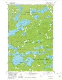
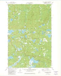
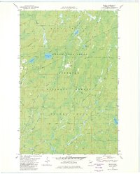
(20)- 1981 Map of Snowbank Lake
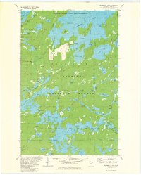 1981 Snowbank Lake1981 Print · USGSLake County and the Boundary Waters are captured here in the early eighties, showing a pristine wilderness of interconnected waterways and portages. Outdoor historians and researchers can trace the Old Pines Trail and locate landmarks like the Boy Scout Camp and the small settlement at Fernberg.3 unique versions available
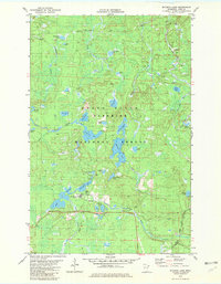
 - 1981 Map of Lake Insula
 1981 Lake Insula1981 Print · USGSThe Boundary Waters region in the early eighties was a vast network of interconnected waterways and primitive paths. Outdoorsmen and historians can trace historic portages and long-distance routes like the Kekekabic Trail and Old Pines Trail past landmarks such as Disappointment Mountain.2 unique versions available
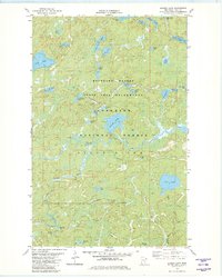
 - 1981 Map of Gabbro Lake, 1982 Print
 1981 Gabbro Lake1982 Print · USGSLake County, Minnesota, is shown here as it remained in the early eighties, a landscape of interconnected waterways and wilderness. You can trace established canoe routes through Gabbro Lake, locate Dam No 1, and find historic portage trails near Turtle Lake.2 unique versions available
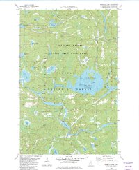
 - 1981 Map of Ojibway Lake, 1982 Print
 1981 Ojibway Lake1982 Print · USGSThe Boundary Waters and Superior National Forest appear in the early eighties as a dense network of glacial lakes and portage trails. Trace wilderness routes between Ojibway Lake, Wood Lake, and the winding Kawishiwi River.2 unique versions available
 - 1981 Map of Farm Lake, 1982 Print
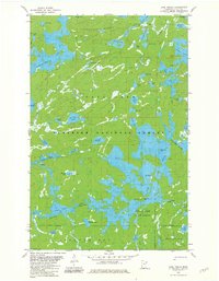
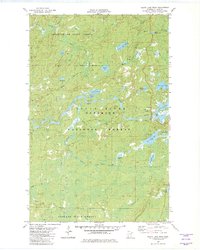
 1981 Farm Lake1982 Print · USGSLake County's wilderness is captured in the early eighties at the intersection of managed timberlands and protected canoe country. Genealogists and historians can trace portage routes and recreational sites like Fall Lake Campground, Fernberg Road, and the Bear Island State Forest.2 unique versions available
 - 1981 Map of Slate Lake West, 1982 Print
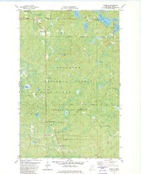
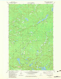
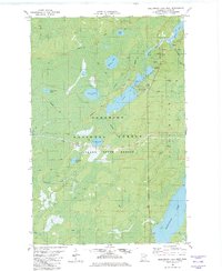
 1981 Slate Lake West1982 Print · USGSLake County's wilderness is captured in the early eighties as a dense network of forests and waterways. Trace the remote settlement of Happy Wanderer or explore the drainage of the Stony River near Slate Lake and Jackpot Lake.2 unique versions available
 - 1981 Map of Bogberry Lake, 1982 Print
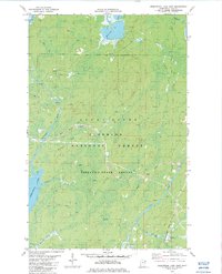
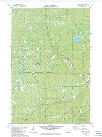
 1981 Bogberry Lake1982 Print · USGSLake County, Minnesota, is shown here in the late seventies, a time when federal management shaped the northern wilderness. Track remote water routes and forestry sites like the Boundary Waters Canoe Area Wilderness and the Experiment Sta (USFS).2 unique versions available
 - 1981 Map of Isabella, 1982 Print
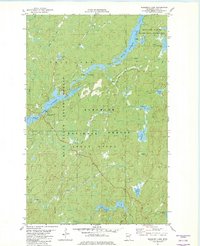
 1981 Isabella1982 Print · USGSLake County was a center for timber and mineral transport in the early eighties, shown here through an intricate network of forest grades and waterways. Researchers can trace the Old Railroad Grade, locate the Isabella Memorial Cem, and explore the roads around Isabella and Murphy City.2 unique versions available
 - 1981 Map of Slate Lake East, 1982 Print
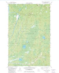
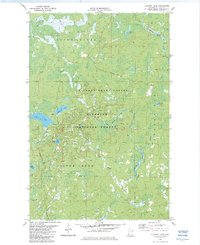
 1981 Slate Lake East1982 Print · USGSThe northern wilderness of Lake County is captured here in the early 1980s, showcasing a pristine landscape of glacial lakes and river systems. Explorers and researchers can trace remote access points like Tomahawk Road, the grounds of Camp Buckskin, and the winding course of the Stony River.2 unique versions available
 - 1981 Map of Mitawan Lake, 1982 Print
 1981 Mitawan Lake1982 Print · USGSThe Superior National Forest is shown in the early 1980s as a landscape transitioning from its logging roots to a recreational wilderness. You can trace the Duluth and Iron Range Railroad (Abandoned) or locate lakefront sites like Mitawan Lake and the Environmental Center (USFS).2 unique versions available
 - 1981 Map of Quadga Lake, 1982 Print
 1981 Quadga Lake1982 Print · USGSThe Boundary Waters region in the early eighties was a pristine maze of glacial lakes and portage trails. Trace the historic canoe routes along the Isabella River and locate remote landmarks like Quadga Lake, Bog Lake, and the Tomahawk Road.2 unique versions available
 - 1981 Map of Isabella Lake, 1982 Print
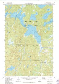
 1981 Isabella Lake1982 Print · USGSThe Lake County backcountry in the early eighties is mapped here as a labyrinth of glacial lakes and portage trails. Outdoorsmen and researchers can trace historical water routes between Isabella Lake, Azure Lake, and the Island River.2 unique versions available
 - 1981 Map of Sawbill Landing, 1983 Print
 1981 Sawbill Landing1983 Print · USGSThe Lake County woods come into focus during the early 1980s, showcasing the intersection of timber transport and the northern wilderness. Genealogists and local historians can trace the routes of the Duluth and Missabe Iron Range and find remote sites like Sawbill Landing and Kelly Landing.2 unique versions available
 - 1982 Map of Isabella Station
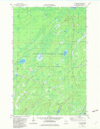
 1982 Isabella Station1982 Print · USGSLake County's timber and transit history is preserved here in the early eighties, showcasing the intersection of massive state and national forests. Genealogists and historians can trace the Duluth Missabe and Iron Range Railroad Grade past Isabella Station and the remote Jay Cee Landing.2 unique versions available
 - 1982 Map of Greenwood Lake East
 1982 Greenwood Lake East1982 Print · USGSLake County's timber and mining country is captured here in the early eighties, as heavy industry operated deep within the northern woods. Researchers can trace the path of the Duluth Missabe and Iron Range Mining Railroad and locate landmarks like Homestead and McDougal Lakes.2 unique versions available
 - 1982 Map of Mt Weber
 1982 Mt Weber1982 Print · USGSLake County's timber and iron country is detailed here in the early eighties, showcasing the intersection of industrial rail and protected forests. Researchers can trace the paths of the Duluth Missabe and Iron Range and an Old RR Grade near Sullivan Lake.2 unique versions available
 - 1982 Map of Whyte
 1982 Whyte1982 Print · USGSLake County's timber and rail history is preserved here in the early 1980s, centered on the intersection of the Finland State Forest and the Superior National Forest. You can trace the Duluth Missabe and Iron Range tracks through Whyte and Scott Junction or locate an Old Railroad Grade.2 unique versions available
 - 1982 Map of Greenwood Lake West
 1982 Greenwood Lake West1982 Print · USGSLake County's north woods are captured here in the early eighties, showcasing a vast network of wilderness lakes and timber lands. Trace industrial and recreational history through features like the Mining Railroad, Sand Lake, and the remote Winter Trails.2 unique versions available
 - 1982 Map of Cloquet Lake, 1983 Print
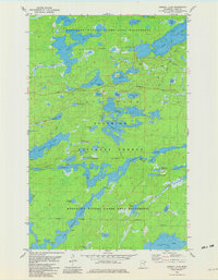
 1982 Cloquet Lake1983 Print · USGSThe Lake County wilderness in the early 1980s reveals a landscape of protected forests and interconnected waterways. Outdoor researchers and local historians can trace the paths of a Winter Trail and Heffelfinger Road through the Finland State Forest.2 unique versions available
 - 1982 Map of Doyle Lake, 1983 Print
 1982 Doyle Lake1983 Print · USGSLake County's northern woods are mapped here in the early eighties as a hub for both forestry and seasonal recreation. Researchers can trace the Old Railroad Grade near Finland or locate the many water bodies including Doyle Lake and Fry Lake.2 unique versions available
End of results
Showing maps 1-20 of 20
Top neighborhoods of Stony River Township
- Baptism Crossing historical maps
- Forest Center historical maps
- Isabella historical maps
- Murphy City historical maps
- Winter historical maps
- Jay See Landing historical maps
See more
Frequently asked questions
- What are the different types of historical maps available for Stony River Township?
- What is the oldest map of Stony River Township?
- Where can I purchase historical maps of Stony River Township for my home or office?
- Where can I download high-res historical maps of Stony River Township?
- Are there historical topographic maps available for Stony River Township?
- Is there historical aerial imagery available for Stony River Township?
- Where are historical maps of Stony River Township sourced from?