1960s Maps of Oslo, Minnesota
Explore 3 historic maps of Oslo from the 1960s. These maps offer a rare glimpse into what life looked like during the 1960s — showing old roads, neighborhoods, homes, and landmarks that have changed or disappeared over time.
Whether you're researching your family's past, planning a metal detecting trip, or studying how Oslo's landscape evolved across the 1960s, these high-resolution maps are a powerful tool for exploring the history of this region.
- Focus on a specific era: All maps on this page are from the 1960s, giving you a focused view of this time period.
- See what’s changed: Compare century-old streets, trails, and buildings to today's modern landscape using overlays and satellite layers.
- Research with precision: Use these maps for genealogy, historical research, land use analysis, or educational projects.
- View, download, or print: Maps are fully viewable online in high resolution, and can be downloaded or printed for your own records.
Start exploring Oslo's history through authentic maps from the 1960s. This is your window into the past.
Oslo, MN maps
(3)- 1966 Map of Oslo NE, 1968 Print
 1966 Oslo NE1968 Print · USGSThe Red River Valley in the mid-sixties shows a landscape of precise township grids and vital rail connections along the Minnesota-North Dakota border. Genealogists can trace rural family sites near Mesopotamia Cem, Oak Park Ch, and the Soo Line rail corridor.
 - 1966 Map of Oslo, 1968 Print
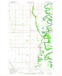 1966 Oslo1968 Print · USGSThe Red River Valley in the mid-sixties shows a landscape defined by sharp river bends and the precision of the SOO LINE railroad. Genealogists and local historians can trace the community of Oslo, family landmarks like Riverside Cem, and the GREAT NORTHERN rail line.3 unique versions available
 - 1967 Map of Thief River Falls
 1967 Thief River Falls1967 Print · USGSThe Red River Valley and the international border come alive in the 1960s, showing a landscape shaped by major rail lines and river commerce. Genealogists and historians can trace the paths of the Great Northern and Soo Line through towns like Thief River Falls, Grafton, and Hallock.
End of results
Showing maps 1-3 of 3
Top cities near Oslo
Frequently asked questions
- What are the different types of historical maps available for Oslo?
- What is the oldest map of Oslo?
- Where can I purchase historical maps of Oslo for my home or office?
- Where can I download high-res historical maps of Oslo?
- Are there historical topographic maps available for Oslo?
- Is there historical aerial imagery available for Oslo?
- Where are historical maps of Oslo sourced from?