1970s Maps of Martin County, Minnesota
Explore 9 historic maps of Martin County from the 1970s. These maps offer a rare glimpse into what life looked like during the 1970s — showing old roads, neighborhoods, homes, and landmarks that have changed or disappeared over time.
Whether you're researching your family's past, planning a metal detecting trip, or studying how Martin County's landscape evolved across the 1970s, these high-resolution maps are a powerful tool for exploring the history of this region.
- Focus on a specific era: All maps on this page are from the 1970s, giving you a focused view of this time period.
- See what’s changed: Compare century-old streets, trails, and buildings to today's modern landscape using overlays and satellite layers.
- Research with precision: Use these maps for genealogy, historical research, land use analysis, or educational projects.
- View, download, or print: Maps are fully viewable online in high resolution, and can be downloaded or printed for your own records.
Start exploring Martin County's history through authentic maps from the 1970s. This is your window into the past.
Martin County, MN maps
(9)- 1970 Map of St James SE, 1972 Print
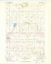
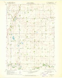 1970 St James SE1972 Print · USGSMartin County agriculture and rural life take center stage in the early seventies, showing a landscape defined by prairie drainage and small townships. Researchers can locate the North Star Cem, the Waverly Ch, and various water bodies like Round Lake and Fox Lake.
 - 1970 Map of Ceylon, 1972 Print
 1970 Ceylon1972 Print · USGSSouthern Minnesota and the Iowa borderlands are captured here in the early 1970s, showing a prairie landscape shaped by drainage and rail. Researchers can trace family sites at Lone Cedar Cem or follow the path of the Chicago and North Western railroad through Ceylon.
 - 1970 Map of Trimont, 1972 Print
 1970 Trimont1972 Print · USGSThe rail-and-water landscape of Martin and Watonwan Counties is captured here in the early seventies. Genealogists and local historians can trace family roots through the grain-and-rail economy of Trimont, the small-town streets of Odin, and the Cedar Lake Cem.
 - 1970 Map of Mountain Lake SE, 1972 Print
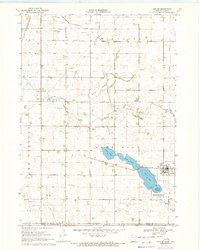
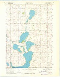
 1970 Mountain Lake SE1972 Print · USGSSouthern Minnesota farm country is captured here in the early seventies as a network of creek-fed townships across four county lines. Genealogists and local historians can trace legacy landmarks like St Olaf Ch Cem, Cedar Hill Cem, and the waters of Fish Lake.
 - 1970 Map of Welcome, 1972 Print
 1970 Welcome1972 Print · USGSWelcome is captured in the early 1970s as a bustling rail crossroads in Martin County during a period of agricultural expansion. Genealogists and local historians can trace the paths of the Milwaukee Road, locate the Emmanuel Cem, or find early civic sites like the Townhall.
 - 1970 Map of Dunnell, 1972 Print
 1970 Dunnell1972 Print · USGSDunnell and the surrounding farmlands of Martin and Emmet counties are captured here in the early 1970s. Researchers can trace family ties through the Lake Fremont Cem, the Chicago and North Western rail corridor, and the grid of Judicial Ditch No 105.
 - 1970 Map of Wilbert, 1972 Print
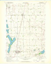
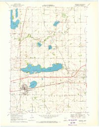
 1970 Wilbert1972 Print · USGSThe Minnesota-Iowa borderlands come to life in the early seventies, showcasing a landscape of glacial lakes and prairie townships. Researchers can locate the Wilbert Townhall, trace family plots at Tenhassen Cem, and explore the shoreline of Okamanpeedan Lake.
 - 1970 Map of Sherburn, 1972 Print
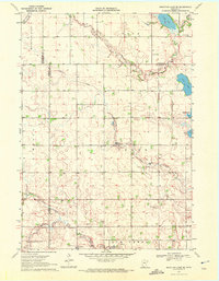
 1970 Sherburn1972 Print · USGSMartin County agriculture and rail transit meet in the early seventies as the interstate highway system begins its expansion. Trace the growth of Sherburn and Welcome or locate ancestral sites like Elm Creek Cem and the Emmanuel Ch.
 - 1970 Map of Alpha, 1972 Print
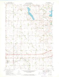 1970 Alpha1972 Print · USGSThe village of Alpha and its surrounding prairie landscape are captured here in the early 1970s, showcasing a rural economy built on rail and water management. Researchers can trace the Chicago Milwaukee St Paul and Pacific line and family-scale operations like the numerous Gravel Pits near Watkins Lake.
End of results
Showing maps 1-9 of 9
Top cities of Martin County
- Fairmont historical maps
- Truman historical maps
- Sherburn historical maps
- Trimont historical maps
- Welcome historical maps
- Ceylon historical maps
See more
Frequently asked questions
- What are the different types of historical maps available for Martin County?
- What is the oldest map of Martin County?
- Where can I purchase historical maps of Martin County for my home or office?
- Where can I download high-res historical maps of Martin County?
- Are there historical topographic maps available for Martin County?
- Is there historical aerial imagery available for Martin County?
- Where are historical maps of Martin County sourced from?